La Rivière-Saint-Sauveur geodata
La Rivière-Saint-Sauveur (Normandy) is a populated place; located in France in Europe/Paris (GMT+2) time zone. With population of 1,664 people, there are 5624 cities with bigger population in this country. Compared to other cities in France, 88% of cities are located further ↓South; 75.6% of cities are located further →East and 99.6% of cities have higher elevation than La Rivière-Saint-Sauveur. Note1
Administrative division(s):
- Level 1: Normandy
- Level 2: Calvados
- Level 3: Arrondissement de Lisieux
- Level 4: La Rivière-Saint-Sauveur
Current local time in La Rivière-Saint-Sauveur:
12:58 PM, SaturdayDifference from your time zone: hours


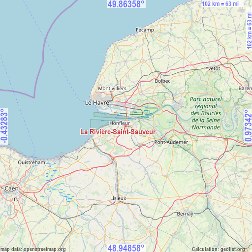
La Rivière-Saint-Sauveur GPS coordinates[2]
49° 24' 29.556" North, 0° 16' 13.08" East
| Map corner | latitude | longitude |
|---|---|---|
| Upper-left | 49.86358°, | -0.43283° |
| Center: | 49.40821°, | 0.2703° |
| Lower-right: | 48.94858°, | 0.97342° |
| Map W x H: | 101.7×101.7 km | = 63.2×63.2mi |
| max Lat: | 51.07786° ⇑12% North |
| La Rivière-Saint-Sauveur: | 49.40821° |
| min Lat: | ⇓88% South 41.3874° |
| min Long | La Rivière-Sai | max Long |
| -5.08615° | 0.2703° | 9.52242° |
| W 24.4%⇐ | ⇒75.6% E |
Elevation
Elevation of La Rivière-Saint-Sauveur is 4 m = 13 ft, and this is 189.7 m = 622 ft below average elevation for this country.
| Max E: |
2333 m = 7654 ft | 99.6% |
| Avg. | 193.7 m = 635 ft | |
| La Rivière-Saint-Sauveur | 4 m = 13 ft | |
Min E: |
-1 m = -3 ft | 0.4% |
See also: France elevation on elevation.city.
Geographical zone
La Rivière-Saint-Sauveur is located in North temperate zone (between Tropic of Cancer and the Arctic Circle). Distance of this North polar circle is 1907.5 km =1185.3 mi to North.| Distance of | km | miles | from La Rivière-Saint-Sauveur |
|---|---|---|---|
| North Pole | 4513.4 | 2804.5 | to North |
| Arctic Circle | 1907.5 | 1185.3 | to North |
| Tropic Cancer | 2887.8 | 1794.4 | to South |
| Equator | 5493.7 | 3413.6 | to South |


Nearby cities:
15 places around La Rivière-Saint-Sauveur: (largest is in red/bold)
• Ablon
2.6 km =1.6 mi,  134°
134°
• Beuzeville
8.8 km =5.5 mi,  143°
143°
• Boulleville
9.6 km =6 mi,  115°
115°
• Conteville
9.2 km =5.7 mi,  83°
83°
• Fatouville-Grestain
4.2 km =2.6 mi,  95°
95°
• Fiquefleur-Équainville
3.8 km =2.4 mi,  107°
107°
• Genneville
4.3 km =2.7 mi,  175°
175°
• Gonneville-sur-Honfleur
3.2 km =2 mi,  214°
214°
• Honfleur
3 km =1.9 mi,  295°
295°
• Rogerville
10.5 km =6.5 mi,  357°
357°
• Saint-Gatien-des-Bois
9 km =5.6 mi,  224°
224°
• Saint-Pierre-du-Val
7.1 km =4.4 mi, 100°
• Sandouville
10.5 km =6.5 mi,  18°
18°
• Villerville
10.3 km =6.4 mi,  265°
265°
• Équemauville
4.8 km =3 mi,  250°
250°
Sources, notices
• [Note1] Compared only with cities in France existing in our database
• [Src1] Map data: © OpenStreetMap contributors (CC-BY-SA)
• [Src2] Other city data from geonames.org with taken over terms of usage.
• [Src3] Geographical zone / Annual Mean Temperature by Robert A. Rohde @ Wikipedia
