Villefranche-de-Rouergue geodata
Villefranche-de-Rouergue (Occitanie) is a seat of a third-order administrative division; located in France in Europe/Paris (GMT+2) time zone. With population of 14,030 people, there are 677 cities with bigger population in this country. Compared to other cities in France, 84.6% of cities are located further ↑North; 56.6% of cities are located further →East and 77.6% of cities have lower elevation than Villefranche-de-Rouergue. Note1
Administrative division(s):
- Level 1: Occitanie
- Level 2: Département de l'Aveyron
- Level 3: Arrondissement de Villefranche-de-Rouergue
- Level 4: Villefranche-de-Rouergue
Current local time in Villefranche-de-Rouergue:
01:14 PM, SaturdayDifference from your time zone: hours


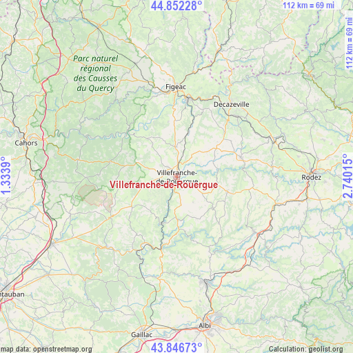
Villefranche-de-Rouergue GPS coordinates[2]
44° 21' 5.976" North, 2° 2' 13.272" East
| Map corner | latitude | longitude |
|---|---|---|
| Upper-left | 44.85228°, | 1.3339° |
| Center: | 44.35166°, | 2.03702° |
| Lower-right: | 43.84673°, | 2.74015° |
| Map W x H: | 111.8×111.8 km | = 69.5×69.5mi |
| max Lat: | 51.07786° ⇑84.6% North |
| Villefranche-de-Rouergue: | 44.35166° |
| min Lat: | ⇓15.4% South 41.3874° |
| min Long | Villefranche-de | max Long |
| -5.08615° | 2.03702° | 9.52242° |
| W 43.4%⇐ | ⇒56.6% E |
Elevation
Elevation of Villefranche-de-Rouergue is 269 m = 883 ft, and this is 75.3 m = 247 ft above average elevation for this country.
| Max E: |
2333 m = 7654 ft | 22.4% |
| Villefranche-de-Rouergue | 269 m 883 ft | |
| Avg. | 193.7 m = 635 ft | |
Min E: |
-1 m = -3 ft | 77.6% |
See also: France elevation on elevation.city.
Geographical zone
Villefranche-de-Rouergue is located in North temperate zone (between Tropic of Cancer and the Arctic Circle). Distance of this Northern Tropic circle is 2325.5 km =1445 mi to South.| Distance of | km | miles | from Villefranche-de-Rouergue |
|---|---|---|---|
| North Pole | 5075.6 | 3153.8 | to North |
| Arctic Circle | 2469.7 | 1534.6 | to North |
| Tropic Cancer | 2325.5 | 1445 | to South |
| Equator | 4931.4 | 3064.2 | to South |


Nearby cities:
15 places around Villefranche-de-Rouergue: (largest is in red/bold)
• Anglars-Saint-Félix
16.5 km =10.3 mi,  61°
61°
• La Fouillade
13.4 km =8.3 mi,  179°
179°
• La Rouquette
7.4 km =4.6 mi,  222°
222°
• Lanuéjouls
13.7 km =8.5 mi,  48°
48°
• Maleville
7.3 km =4.5 mi, 46°
• Martiel
9.5 km =5.9 mi,  286°
286°
• Monteils
10 km =6.2 mi,  198°
198°
• Morlhon-le-Haut
3.7 km =2.3 mi,  145°
145°
• Najac
15.5 km =9.6 mi, 197°
• Rieupeyroux
16.7 km =10.4 mi,  106°
106°
• Sanvensa
6.8 km =4.2 mi,  171°
171°
• Savignac
5.7 km =3.5 mi,  277°
277°
• Toulonjac
4.4 km =2.7 mi,  318°
318°
• Vailhourles
11.6 km =7.2 mi,  243°
243°
• Villeneuve
9.1 km =5.7 mi,  358°
358°
Sources, notices
• [Note1] Compared only with cities in France existing in our database
• [Src1] Map data: © OpenStreetMap contributors (CC-BY-SA)
• [Src2] Other city data from geonames.org with taken over terms of usage.
• [Src3] Geographical zone / Annual Mean Temperature by Robert A. Rohde @ Wikipedia
