Monteils geodata
Monteils (Occitanie) is a populated place; located in France in Europe/Paris (GMT+2) time zone. With population of 620 people, there are 12983 cities with bigger population in this country. Compared to other cities in France, 85% of cities are located further ↑North; 57.1% of cities are located further →East and 73.7% of cities have lower elevation than Monteils. Note1
Administrative division(s):
- Level 1: Occitanie
- Level 2: Département de l'Aveyron
- Level 3: Arrondissement de Villefranche-de-Rouergue
- Level 4: Monteils


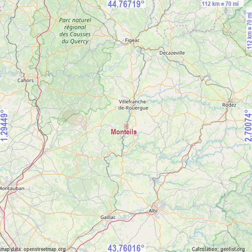
Monteils GPS coordinates[2]
44° 15' 56.988" North, 1° 59' 51.432" East
| Map corner | latitude | longitude |
|---|---|---|
| Upper-left | 44.76719°, | 1.29449° |
| Center: | 44.26583°, | 1.99762° |
| Lower-right: | 43.76016°, | 2.70074° |
| Map W x H: | 112×112 km | = 69.6×69.6mi |
| max Lat: | 51.07786° ⇑85% North |
| Monteils: | 44.26583° |
| min Lat: | ⇓15% South 41.3874° |
| min Long | Monteils | max Long |
| -5.08615° | 1.99762° | 9.52242° |
| W 42.9%⇐ | ⇒57.1% E |
Elevation
Elevation of Monteils is 240 m = 787 ft, and this is 46.3 m = 152 ft above average elevation for this country.
| Max E: |
2333 m = 7654 ft | 26.3% |
| Monteils | 240 m 787 ft | |
| Avg. | 193.7 m = 635 ft | |
Min E: |
-1 m = -3 ft | 73.7% |
See also: France elevation on elevation.city.
Geographical zone
Monteils is located in North temperate zone (between Tropic of Cancer and the Arctic Circle). Distance of this Northern Tropic circle is 2316 km =1439.1 mi to South.| Distance of | km | miles | from Monteils |
|---|---|---|---|
| North Pole | 5085.2 | 3159.8 | to North |
| Arctic Circle | 2479.3 | 1540.6 | to North |
| Tropic Cancer | 2316 | 1439.1 | to South |
| Equator | 4921.9 | 3058.3 | to South |


Nearby cities:
15 places around Monteils: (largest is in red/bold)
• Caylus
18.3 km =11.4 mi,  259°
259°
• La Fouillade
5.2 km =3.2 mi,  139°
139°
• La Rouquette
4.4 km =2.7 mi,  335°
335°
• La Salvetat-Peyralès
17.2 km =10.7 mi,  107°
107°
• Laguépie
13.4 km =8.3 mi,  190°
190°
• Maleville
16.8 km =10.4 mi,  29°
29°
• Martiel
13.7 km =8.5 mi,  334°
334°
• Morlhon-le-Haut
8.4 km =5.2 mi,  38°
38°
• Najac
5.5 km =3.4 mi,  197°
197°
• Sanvensa
5 km =3.1 mi,  55°
55°
• Savignac
10.6 km =6.6 mi,  346°
346°
• Toulonjac
12.8 km =8 mi,  0°
0°
• Vailhourles
8.5 km =5.3 mi,  301°
301°
• Varen
14.5 km =9 mi,  214°
214°
• Villefranche-de-Rouergue
10 km =6.2 mi,  18°
18°
Sources, notices
• [Note1] Compared only with cities in France existing in our database
• [Src1] Map data: © OpenStreetMap contributors (CC-BY-SA)
• [Src2] Other city data from geonames.org with taken over terms of usage.
• [Src3] Geographical zone / Annual Mean Temperature by Robert A. Rohde @ Wikipedia
