Villaines-les-Rochers geodata
Villaines-les-Rochers (Centre) is a populated place; located in France in Europe/Paris (GMT+2) time zone. With population of 957 people, there are 9150 cities with bigger population in this country. Compared to other cities in France, 52.7% of cities are located further ↑North; 73.4% of cities are located further →East and 75.4% of cities have higher elevation than Villaines-les-Rochers. Note1
Administrative division(s):
- Level 1: Centre
- Level 2: Département d'Indre-et-Loire
- Level 3: Arrondissement de Tours
- Level 4: Villaines-les-Rochers
Current local time in Villaines-les-Rochers:
11:25 AM, SaturdayDifference from your time zone: hours


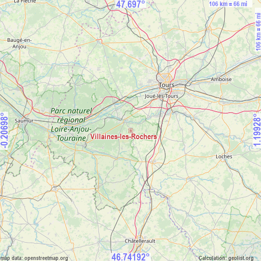
Villaines-les-Rochers GPS coordinates[2]
47° 13' 17.796" North, 0° 29' 46.14" East
| Map corner | latitude | longitude |
|---|---|---|
| Upper-left | 47.697°, | -0.20698° |
| Center: | 47.22161°, | 0.49615° |
| Lower-right: | 46.74192°, | 1.19928° |
| Map W x H: | 106.2×106.2 km | = 66×66mi |
| max Lat: | 51.07786° ⇑52.7% North |
| Villaines-les-Rochers: | 47.22161° |
| min Lat: | ⇓47.3% South 41.3874° |
| min Long | Villaines-les-R | max Long |
| -5.08615° | 0.49615° | 9.52242° |
| W 26.6%⇐ | ⇒73.4% E |
Elevation
Elevation of Villaines-les-Rochers is 66 m = 217 ft, and this is 127.7 m = 419 ft below average elevation for this country.
| Max E: |
2333 m = 7654 ft | 75.4% |
| Avg. | 193.7 m = 635 ft | |
| Villaines-les-Rochers | 66 m = 217 ft | |
Min E: |
-1 m = -3 ft | 24.6% |
See also: France elevation on elevation.city.
Geographical zone
Villaines-les-Rochers is located in North temperate zone (between Tropic of Cancer and the Arctic Circle). Distance of this North polar circle is 2150.6 km =1336.3 mi to North.| Distance of | km | miles | from Villaines-les-Rochers |
|---|---|---|---|
| North Pole | 4756.5 | 2955.6 | to North |
| Arctic Circle | 2150.6 | 1336.3 | to North |
| Tropic Cancer | 2644.6 | 1643.3 | to South |
| Equator | 5250.6 | 3262.6 | to South |


Nearby cities:
15 places around Villaines-les-Rochers: (largest is in red/bold)
• Artannes-sur-Indre
9.8 km =6.1 mi,  53°
53°
• Avon-les-Roches
8.1 km =5 mi,  206°
206°
• Azay-le-Rideau
5.1 km =3.2 mi,  338°
338°
• Cheillé
8.1 km =5 mi,  302°
302°
• Crouzilles
11.2 km =7 mi,  194°
194°
• Druye
10.2 km =6.3 mi,  18°
18°
• Lignières-de-Touraine
10.3 km =6.4 mi,  324°
324°
• Monts
11.5 km =7.1 mi,  57°
57°
• Panzoult
11.1 km =6.9 mi,  220°
220°
• Pont-de-Ruan
7.5 km =4.7 mi, 53°
• Saché
4.6 km =2.9 mi, 52°
• Saint-Épain
9.1 km =5.7 mi,  160°
160°
• Thilouze
6.3 km =3.9 mi,  87°
87°
• Vallères
10.1 km =6.3 mi,  350°
350°
• Villeperdue
10.7 km =6.6 mi,  101°
101°
Sources, notices
• [Note1] Compared only with cities in France existing in our database
• [Src1] Map data: © OpenStreetMap contributors (CC-BY-SA)
• [Src2] Other city data from geonames.org with taken over terms of usage.
• [Src3] Geographical zone / Annual Mean Temperature by Robert A. Rohde @ Wikipedia
