Azay-le-Rideau geodata
Azay-le-Rideau (Centre) is a populated place; located in France in Europe/Paris (GMT+2) time zone. With population of 3,275 people, there are 2975 cities with bigger population in this country. Compared to other cities in France, 52.1% of cities are located further ↑North; 73.7% of cities are located further →East and 66.6% of cities have higher elevation than Azay-le-Rideau. Note1
Administrative division(s):
- Level 1: Centre
- Level 2: Département d'Indre-et-Loire
- Level 3: Arrondissement de Tours
- Level 4: Azay-le-Rideau


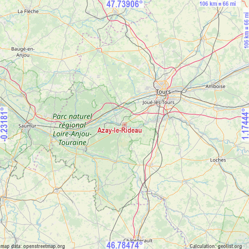
Azay-le-Rideau GPS coordinates[2]
47° 15' 50.58" North, 0° 28' 16.752" East
| Map corner | latitude | longitude |
|---|---|---|
| Upper-left | 47.73906°, | -0.23181° |
| Center: | 47.26405°, | 0.47132° |
| Lower-right: | 46.78474°, | 1.17444° |
| Map W x H: | 106.1×106.1 km | = 65.9×65.9mi |
| max Lat: | 51.07786° ⇑52.1% North |
| Azay-le-Rideau: | 47.26405° |
| min Lat: | ⇓47.9% South 41.3874° |
| min Long | Azay-le-Rideau | max Long |
| -5.08615° | 0.47132° | 9.52242° |
| W 26.3%⇐ | ⇒73.7% E |
Elevation
Elevation of Azay-le-Rideau is 86 m = 282 ft, and this is 107.7 m = 353 ft below average elevation for this country.
| Max E: |
2333 m = 7654 ft | 66.6% |
| Avg. | 193.7 m = 635 ft | |
| Azay-le-Rideau | 86 m = 282 ft | |
Min E: |
-1 m = -3 ft | 33.4% |
See also: France elevation on elevation.city.
Geographical zone
Azay-le-Rideau is located in North temperate zone (between Tropic of Cancer and the Arctic Circle). Distance of this North polar circle is 2145.9 km =1333.4 mi to North.| Distance of | km | miles | from Azay-le-Rideau |
|---|---|---|---|
| North Pole | 4751.8 | 2952.6 | to North |
| Arctic Circle | 2145.9 | 1333.4 | to North |
| Tropic Cancer | 2649.4 | 1646.3 | to South |
| Equator | 5255.3 | 3265.5 | to South |


Nearby cities:
15 places around Azay-le-Rideau: (largest is in red/bold)
• Artannes-sur-Indre
9.8 km =6.1 mi,  83°
83°
• Bréhémont
9.1 km =5.7 mi,  292°
292°
• Cheillé
5 km =3.1 mi,  266°
266°
• Cinq-Mars-la-Pile
9.2 km =5.7 mi,  354°
354°
• Druye
7.1 km =4.4 mi,  45°
45°
• La Chapelle-aux-Naux
6.8 km =4.2 mi,  330°
330°
• Langeais
8.7 km =5.4 mi,  322°
322°
• Lignières-de-Touraine
5.5 km =3.4 mi,  312°
312°
• Pont-de-Ruan
7.9 km =4.9 mi,  92°
92°
• Rivarennes
8.9 km =5.5 mi, 272°
• Saché
5.8 km =3.6 mi,  108°
108°
• Thilouze
9.3 km =5.8 mi,  118°
118°
• Vallères
5.3 km =3.3 mi,  2°
2°
• Villaines-les-Rochers
5.1 km =3.2 mi,  158°
158°
• Villandry
9 km =5.6 mi,  19°
19°
In other languages:
- In Spanish: Castillo de Azay-le-Rideau
- In German: Schloss Azay-le-Rideau
- In Italian: Azay-le-Rideau, Castello di Azay-le-Rideau
- In Russian: Азэ-лё-Ридо, Азе-ле-Ридо
- In Chinese: 阿泽莱里多
Sources, notices
• [Note1] Compared only with cities in France existing in our database
• [Src1] Map data: © OpenStreetMap contributors (CC-BY-SA)
• [Src2] Other city data from geonames.org with taken over terms of usage.
• [Src3] Geographical zone / Annual Mean Temperature by Robert A. Rohde @ Wikipedia
