Vienne geodata
Vienne (Auvergne-Rhône-Alpes) is a seat of a third-order administrative division; located in France in Europe/Paris (GMT+2) time zone. With population of 32,293 people, there are 242 cities with bigger population in this country. Compared to other cities in France, 73.8% of cities are located further ↑North; 76.2% of cities are located further ←West and 64.2% of cities have lower elevation than Vienne. Note1
Administrative division(s):
- Level 1: Auvergne-Rhône-Alpes
- Level 2: Département de l'Isère
- Level 3: Arrondissement de Vienne
- Level 4: Vienne


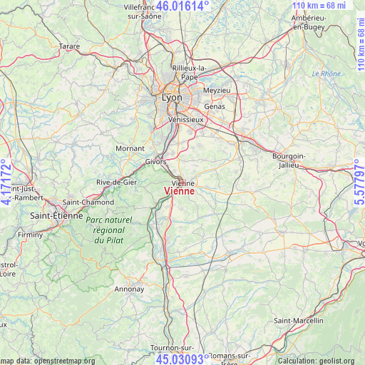
Vienne GPS coordinates[2]
45° 31' 32.484" North, 4° 52' 29.424" East
| Map corner | latitude | longitude |
|---|---|---|
| Upper-left | 46.01614°, | 4.17172° |
| Center: | 45.52569°, | 4.87484° |
| Lower-right: | 45.03093°, | 5.57797° |
| Map W x H: | 109.5×109.5 km | = 68×68mi |
| max Lat: | 51.07786° ⇑73.8% North |
| Vienne: | 45.52569° |
| min Lat: | ⇓26.2% South 41.3874° |
| min Long | Vienne | max Long |
| -5.08615° | 4.87484° | 9.52242° |
| W 76.2%⇐ | ⇒23.8% E |
Elevation
Elevation of Vienne is 190 m = 623 ft, and this is 3.7 m = 12 ft below average elevation for this country.
| Max E: |
2333 m = 7654 ft | 35.8% |
| Avg. | 193.7 m = 635 ft | |
| Vienne | 190 m = 623 ft | |
Min E: |
-1 m = -3 ft | 64.2% |
See also: France elevation on elevation.city.
Geographical zone
Vienne is located in North temperate zone (between Tropic of Cancer and the Arctic Circle). Distance of this North polar circle is 2339.2 km =1453.5 mi to North.| Distance of | km | miles | from Vienne |
|---|---|---|---|
| North Pole | 4945.1 | 3072.7 | to North |
| Arctic Circle | 2339.2 | 1453.5 | to North |
| Tropic Cancer | 2456.1 | 1526.1 | to South |
| Equator | 5062 | 3145.4 | to South |


Nearby cities:
15 places around Vienne: (largest is in red/bold)
• Ampuis
6.5 km =4 mi,  231°
231°
• Chasse-sur-Rhône
7.8 km =4.8 mi,  319°
319°
• Chuzelles
6.6 km =4.1 mi,  1°
1°
• Estrablin
6.9 km =4.3 mi,  99°
99°
• Jardin
4.2 km =2.6 mi,  141°
141°
• Les Côtes-d'Arey
7.7 km =4.8 mi,  184°
184°
• Loire-sur-Rhône
6.4 km =4 mi,  294°
294°
• Pont-Évêque
2.8 km =1.7 mi,  74°
74°
• Reventin-Vaugris
7.1 km =4.4 mi,  200°
200°
• Saint-Cyr-sur-le-Rhône
2.1 km =1.3 mi,  237°
237°
• Saint-Romain-en-Gal
1.3 km =0.8 mi,  307°
307°
• Sainte-Colombe
0.6 km =0.4 mi,  266°
266°
• Serpaize
4.9 km =3 mi,  42°
42°
• Seyssuel
4.4 km =2.7 mi,  325°
325°
• Villette-de-Vienne
7.9 km =4.9 mi,  23°
23°
Sources, notices
• [Note1] Compared only with cities in France existing in our database
• [Src1] Map data: © OpenStreetMap contributors (CC-BY-SA)
• [Src2] Other city data from geonames.org with taken over terms of usage.
• [Src3] Geographical zone / Annual Mean Temperature by Robert A. Rohde @ Wikipedia
