Loire-sur-Rhône geodata
Loire-sur-Rhône (Auvergne-Rhône-Alpes) is a populated place; located in France in Europe/Paris (GMT+2) time zone. With population of 2,244 people, there are 4288 cities with bigger population in this country. Compared to other cities in France, 73.4% of cities are located further ↑North; 75% of cities are located further ←West and 84% of cities have lower elevation than Loire-sur-Rhône. Note1
Administrative division(s):
- Level 1: Auvergne-Rhône-Alpes
- Level 2: Département du Rhône
- Level 3: Arrondissement de Lyon
- Level 4: Loire-sur-Rhône


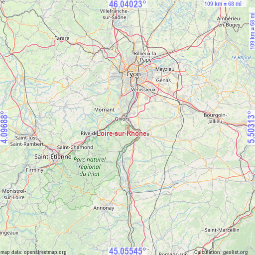
Loire-sur-Rhône GPS coordinates[2]
45° 33' 0" North, 4° 48' 0" East
| Map corner | latitude | longitude |
|---|---|---|
| Upper-left | 46.04023°, | 4.09688° |
| Center: | 45.55°, | 4.8° |
| Lower-right: | 45.05545°, | 5.50313° |
| Map W x H: | 109.5×109.5 km | = 68×68mi |
| max Lat: | 51.07786° ⇑73.4% North |
| Loire-sur-Rhône: | 45.55° |
| min Lat: | ⇓26.6% South 41.3874° |
| min Long | Loire-sur-Rhôn | max Long |
| -5.08615° | 4.8° | 9.52242° |
| W 75%⇐ | ⇒25% E |
Elevation
Elevation of Loire-sur-Rhône is 334 m = 1096 ft, and this is 140.3 m = 460 ft above average elevation for this country.
| Max E: |
2333 m = 7654 ft | 16% |
| Loire-sur-Rhône | 334 m 1096 ft | |
| Avg. | 193.7 m = 635 ft | |
Min E: |
-1 m = -3 ft | 84% |
See also: France elevation on elevation.city.
Geographical zone
Loire-sur-Rhône is located in North temperate zone (between Tropic of Cancer and the Arctic Circle). Distance of this North polar circle is 2336.5 km =1451.8 mi to North.| Distance of | km | miles | from Loire-sur-Rhône |
|---|---|---|---|
| North Pole | 4942.4 | 3071.1 | to North |
| Arctic Circle | 2336.5 | 1451.8 | to North |
| Tropic Cancer | 2458.8 | 1527.8 | to South |
| Equator | 5064.7 | 3147.1 | to South |


Nearby cities:
15 places around Loire-sur-Rhône: (largest is in red/bold)
• Ampuis
6.8 km =4.2 mi,  173°
173°
• Chasse-sur-Rhône
3.3 km =2.1 mi,  13°
13°
• Chuzelles
7.1 km =4.4 mi,  57°
57°
• Communay
6.6 km =4.1 mi,  24°
24°
• Givors
5.1 km =3.2 mi,  331°
331°
• Grigny
6.5 km =4 mi,  353°
353°
• Les Haies
6.5 km =4 mi,  218°
218°
• Saint-Cyr-sur-le-Rhône
5.6 km =3.5 mi,  132°
132°
• Saint-Romain-en-Gal
5.2 km =3.2 mi,  111°
111°
• Saint-Romain-en-Gier
7.4 km =4.6 mi,  283°
283°
• Sainte-Colombe
5.9 km =3.7 mi,  117°
117°
• Seyssuel
3.5 km =2.2 mi,  74°
74°
• Ternay
5.9 km =3.7 mi, 8°
• Vienne
6.4 km =4 mi, 114°
• Échalas
6.6 km =4.1 mi,  271°
271°
Sources, notices
• [Note1] Compared only with cities in France existing in our database
• [Src1] Map data: © OpenStreetMap contributors (CC-BY-SA)
• [Src2] Other city data from geonames.org with taken over terms of usage.
• [Src3] Geographical zone / Annual Mean Temperature by Robert A. Rohde @ Wikipedia
