Seyssuel geodata
Seyssuel (Auvergne-Rhône-Alpes) is a populated place; located in France in Europe/Paris (GMT+2) time zone. With population of 2,044 people, there are 4697 cities with bigger population in this country. Compared to other cities in France, 73.3% of cities are located further ↑North; 75.7% of cities are located further ←West and 81.5% of cities have lower elevation than Seyssuel. Note1
Administrative division(s):
- Level 1: Auvergne-Rhône-Alpes
- Level 2: Département de l'Isère
- Level 3: Arrondissement de Vienne
- Level 4: Seyssuel


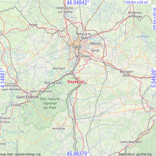
Seyssuel GPS coordinates[2]
45° 33' 29.736" North, 4° 50' 35.268" East
| Map corner | latitude | longitude |
|---|---|---|
| Upper-left | 46.04842°, | 4.14001° |
| Center: | 45.55826°, | 4.84313° |
| Lower-right: | 45.06379°, | 5.54626° |
| Map W x H: | 109.5×109.5 km | = 68×68mi |
| max Lat: | 51.07786° ⇑73.3% North |
| Seyssuel: | 45.55826° |
| min Lat: | ⇓26.7% South 41.3874° |
| min Long | Seyssuel | max Long |
| -5.08615° | 4.84313° | 9.52242° |
| W 75.7%⇐ | ⇒24.3% E |
Elevation
Elevation of Seyssuel is 305 m = 1001 ft, and this is 111.3 m = 365 ft above average elevation for this country.
| Max E: |
2333 m = 7654 ft | 18.5% |
| Seyssuel | 305 m 1001 ft | |
| Avg. | 193.7 m = 635 ft | |
Min E: |
-1 m = -3 ft | 81.5% |
See also: France elevation on elevation.city.
Geographical zone
Seyssuel is located in North temperate zone (between Tropic of Cancer and the Arctic Circle). Distance of this North polar circle is 2335.6 km =1451.3 mi to North.| Distance of | km | miles | from Seyssuel |
|---|---|---|---|
| North Pole | 4941.5 | 3070.5 | to North |
| Arctic Circle | 2335.6 | 1451.3 | to North |
| Tropic Cancer | 2459.7 | 1528.4 | to South |
| Equator | 5065.6 | 3147.6 | to South |


Nearby cities:
15 places around Seyssuel: (largest is in red/bold)
• Chasse-sur-Rhône
3.4 km =2.1 mi,  310°
310°
• Chuzelles
4 km =2.5 mi,  41°
41°
• Communay
5.2 km =3.2 mi,  352°
352°
• Givors
6.8 km =4.2 mi,  301°
301°
• Grigny
7 km =4.3 mi,  323°
323°
• Loire-sur-Rhône
3.5 km =2.2 mi,  254°
254°
• Pont-Évêque
5.9 km =3.7 mi,  119°
119°
• Saint-Cyr-sur-le-Rhône
4.8 km =3 mi,  171°
171°
• Saint-Romain-en-Gal
3.2 km =2 mi,  152°
152°
• Sainte-Colombe
4.1 km =2.5 mi, 153°
• Serpaize
5.8 km =3.6 mi,  90°
90°
• Simandres
7.2 km =4.5 mi,  18°
18°
• Ternay
5.5 km =3.4 mi,  332°
332°
• Vienne
4.4 km =2.7 mi, 145°
• Villette-de-Vienne
6.7 km =4.2 mi,  57°
57°
Sources, notices
• [Note1] Compared only with cities in France existing in our database
• [Src1] Map data: © OpenStreetMap contributors (CC-BY-SA)
• [Src2] Other city data from geonames.org with taken over terms of usage.
• [Src3] Geographical zone / Annual Mean Temperature by Robert A. Rohde @ Wikipedia
