Vico geodata
Vico (Corsica) is a populated place; located in France in Europe/Paris (GMT+2) time zone. With population of 947 people, there are 9227 cities with bigger population in this country. Compared to other cities in France, 99.8% of cities are located further ↑North; 99.5% of cities are located further ←West and 91.9% of cities have lower elevation than Vico. Note1
Administrative division(s):
- Level 1: Corsica
- Level 2: Département de la Corse-du-Sud
- Level 3: Arrondissement d’Ajaccio
- Level 4: Vico


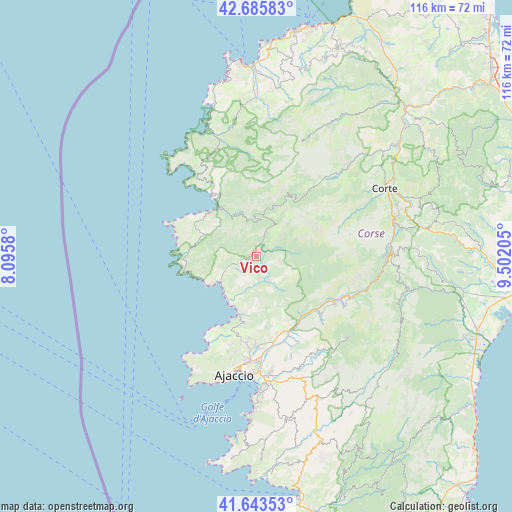
Vico GPS coordinates[2]
42° 10' 0.588" North, 8° 47' 56.112" East
| Map corner | latitude | longitude |
|---|---|---|
| Upper-left | 42.68583°, | 8.0958° |
| Center: | 42.16683°, | 8.79892° |
| Lower-right: | 41.64353°, | 9.50205° |
| Map W x H: | 115.9×115.9 km | = 72×72mi |
| max Lat: | 51.07786° ⇑99.8% North |
| Vico: | 42.16683° |
| min Lat: | ⇓0.2% South 41.3874° |
| min Long | Vico | max Long |
| -5.08615° | 8.79892° | 9.52242° |
| W 99.5%⇐ | ⇒0.5% E |
Elevation
Elevation of Vico is 473 m = 1552 ft, and this is 279.3 m = 916 ft above average elevation for this country.
| Max E: |
2333 m = 7654 ft | 8.1% |
| Vico | 473 m 1552 ft | |
| Avg. | 193.7 m = 635 ft | |
Min E: |
-1 m = -3 ft | 91.9% |
See also: France elevation on elevation.city.
Geographical zone
Vico is located in North temperate zone (between Tropic of Cancer and the Arctic Circle). Distance of this Northern Tropic circle is 2082.6 km =1294.1 mi to South.| Distance of | km | miles | from Vico |
|---|---|---|---|
| North Pole | 5318.5 | 3304.8 | to North |
| Arctic Circle | 2712.7 | 1685.6 | to North |
| Tropic Cancer | 2082.6 | 1294.1 | to South |
| Equator | 4688.5 | 2913.3 | to South |


Nearby cities:
15 places around Vico: (largest is in red/bold)
• Afa
20.3 km =12.6 mi,  180°
180°
• Ajaccio
28 km =17.4 mi,  190°
190°
• Alata
21.7 km =13.5 mi, 192°
• Appietto
17.1 km =10.6 mi, 188°
• Bastelica
27.8 km =17.3 mi,  130°
130°
• Calcatoggio
15.6 km =9.7 mi, 189°
• Cargèse
17.1 km =10.6 mi,  258°
258°
• Cauro
29.3 km =18.2 mi,  160°
160°
• Coggia Maio
6 km =3.7 mi,  212°
212°
• Cuttoli-Corticchiato
22.6 km =14 mi,  154°
154°
• Ota
11 km =6.8 mi,  336°
336°
• Peri
20.8 km =12.9 mi, 151°
• Sarrola
15.8 km =9.8 mi,  166°
166°
• Venaco
31.6 km =19.6 mi,  76°
76°
• Vivario
30.7 km =19.1 mi,  89°
89°
Sources, notices
• [Note1] Compared only with cities in France existing in our database
• [Src1] Map data: © OpenStreetMap contributors (CC-BY-SA)
• [Src2] Other city data from geonames.org with taken over terms of usage.
• [Src3] Geographical zone / Annual Mean Temperature by Robert A. Rohde @ Wikipedia
