Ota geodata
Ota (Corsica) is a populated place; located in France in Europe/Paris (GMT+2) time zone. With population of 550 people, there are 14213 cities with bigger population in this country. Compared to other cities in France, 99.7% of cities are located further ↑North; 99.5% of cities are located further ←West and 84.4% of cities have lower elevation than Ota. Note1
Administrative division(s):
- Level 1: Corsica
- Level 2: Département de la Corse-du-Sud
- Level 3: Arrondissement d’Ajaccio
- Level 4: Ota


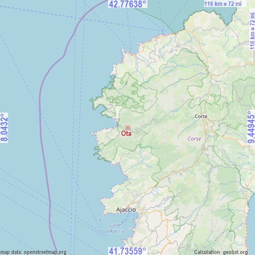
Ota GPS coordinates[2]
42° 15' 29.268" North, 8° 44' 46.752" East
| Map corner | latitude | longitude |
|---|---|---|
| Upper-left | 42.77638°, | 8.0432° |
| Center: | 42.25813°, | 8.74632° |
| Lower-right: | 41.73559°, | 9.44945° |
| Map W x H: | 115.7×115.7 km | = 71.9×71.9mi |
| max Lat: | 51.07786° ⇑99.7% North |
| Ota: | 42.25813° |
| min Lat: | ⇓0.3% South 41.3874° |
| min Long | Ota | max Long |
| -5.08615° | 8.74632° | 9.52242° |
| W 99.5%⇐ | ⇒0.5% E |
Elevation
Elevation of Ota is 340 m = 1115 ft, and this is 146.3 m = 480 ft above average elevation for this country.
| Max E: |
2333 m = 7654 ft | 15.6% |
| Ota | 340 m 1115 ft | |
| Avg. | 193.7 m = 635 ft | |
Min E: |
-1 m = -3 ft | 84.4% |
See also: France elevation on elevation.city.
Geographical zone
Ota is located in North temperate zone (between Tropic of Cancer and the Arctic Circle). Distance of this Northern Tropic circle is 2092.7 km =1300.3 mi to South.| Distance of | km | miles | from Ota |
|---|---|---|---|
| North Pole | 5308.4 | 3298.5 | to North |
| Arctic Circle | 2702.5 | 1679.3 | to North |
| Tropic Cancer | 2092.7 | 1300.3 | to South |
| Equator | 4698.7 | 2919.6 | to South |


Nearby cities:
15 places around Ota: (largest is in red/bold)
• Afa
30.8 km =19.1 mi,  171°
171°
• Alata
31.3 km =19.4 mi,  180°
180°
• Appietto
27.2 km =16.9 mi, 176°
• Calcatoggio
25.6 km =15.9 mi, 176°
• Calenzana
29.2 km =18.1 mi,  17°
17°
• Calvi
34.2 km =21.3 mi,  1°
1°
• Cargèse
18.4 km =11.4 mi,  222°
222°
• Coggia Maio
15.3 km =9.5 mi, 176°
• Corte
33.6 km =20.9 mi,  80°
80°
• Cuttoli-Corticchiato
33.6 km =20.9 mi,  155°
155°
• Peri
31.8 km =19.8 mi,  153°
153°
• Poggio-di-Venaco
36.2 km =22.5 mi,  89°
89°
• Sarrola
26.8 km =16.7 mi, 162°
• Venaco
35.2 km =21.9 mi, 94°
• Vico
11 km =6.8 mi, 156°
Sources, notices
• [Note1] Compared only with cities in France existing in our database
• [Src1] Map data: © OpenStreetMap contributors (CC-BY-SA)
• [Src2] Other city data from geonames.org with taken over terms of usage.
• [Src3] Geographical zone / Annual Mean Temperature by Robert A. Rohde @ Wikipedia
