Afa geodata
Afa (Corsica) is a populated place; located in France in Europe/Paris (GMT+2) time zone. With population of 2,157 people, there are 4460 cities with bigger population in this country. Compared to other cities in France, 99.8% of cities are located further ↑North; 99.5% of cities are located further ←West and 66.1% of cities have lower elevation than Afa. Note1
Administrative division(s):
- Level 1: Corsica
- Level 2: Département de la Corse-du-Sud
- Level 3: Arrondissement d’Ajaccio
- Level 4: Afa


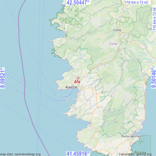
Afa GPS coordinates[2]
41° 59' 2.256" North, 8° 47' 53.988" East
| Map corner | latitude | longitude |
|---|---|---|
| Upper-left | 42.50447°, | 8.09521° |
| Center: | 41.98396°, | 8.79833° |
| Lower-right: | 41.45916°, | 9.50146° |
| Map W x H: | 116.2×116.2 km | = 72.2×72.2mi |
| max Lat: | 51.07786° ⇑99.8% North |
| Afa: | 41.98396° |
| min Lat: | ⇓0.2% South 41.3874° |
| min Long | Afa | max Long |
| -5.08615° | 8.79833° | 9.52242° |
| W 99.5%⇐ | ⇒0.5% E |
Elevation
Elevation of Afa is 199 m = 653 ft, and this is 5.3 m = 17 ft above average elevation for this country.
| Max E: |
2333 m = 7654 ft | 33.9% |
| Afa | 199 m 653 ft | |
| Avg. | 193.7 m = 635 ft | |
Min E: |
-1 m = -3 ft | 66.1% |
See also: France elevation on elevation.city.
Geographical zone
Afa is located in North temperate zone (between Tropic of Cancer and the Arctic Circle). Distance of this Northern Tropic circle is 2062.3 km =1281.5 mi to South.| Distance of | km | miles | from Afa |
|---|---|---|---|
| North Pole | 5338.9 | 3317.4 | to North |
| Arctic Circle | 2733 | 1698.2 | to North |
| Tropic Cancer | 2062.3 | 1281.5 | to South |
| Equator | 4668.2 | 2900.7 | to South |


Nearby cities:
15 places around Afa: (largest is in red/bold)
• Ajaccio
8.8 km =5.5 mi,  214°
214°
• Alata
4.7 km =2.9 mi,  259°
259°
• Albitreccia
18 km =11.2 mi,  138°
138°
• Appietto
4.2 km =2.6 mi,  323°
323°
• Bastelica
21.3 km =13.2 mi,  84°
84°
• Calcatoggio
5.5 km =3.4 mi,  333°
333°
• Cauro
12.1 km =7.5 mi,  127°
127°
• Coggia Maio
15.6 km =9.7 mi,  348°
348°
• Coti-Chiavari
23.6 km =14.7 mi,  185°
185°
• Cuttoli-Corticchiato
9.8 km =6.1 mi,  90°
90°
• Grosseto-Prugna
18.6 km =11.6 mi, 132°
• Peri
10.3 km =6.4 mi, 77°
• Pietrosella
16.9 km =10.5 mi,  166°
166°
• Sarrola
6.1 km =3.8 mi,  36°
36°
• Vico
20.3 km =12.6 mi,  0°
0°
Sources, notices
• [Note1] Compared only with cities in France existing in our database
• [Src1] Map data: © OpenStreetMap contributors (CC-BY-SA)
• [Src2] Other city data from geonames.org with taken over terms of usage.
• [Src3] Geographical zone / Annual Mean Temperature by Robert A. Rohde @ Wikipedia
