Veyrier-du-Lac geodata
Veyrier-du-Lac (Auvergne-Rhône-Alpes) is a populated place; located in France in Europe/Paris (GMT+2) time zone. With population of 2,305 people, there are 4187 cities with bigger population in this country. Compared to other cities in France, 67.9% of cities are located further ↑North; 89.1% of cities are located further ←West and 95.8% of cities have lower elevation than Veyrier-du-Lac. Note1
Administrative division(s):
- Level 1: Auvergne-Rhône-Alpes
- Level 2: Haute-Savoie
- Level 3: Annecy
- Level 4: Veyrier-du-Lac


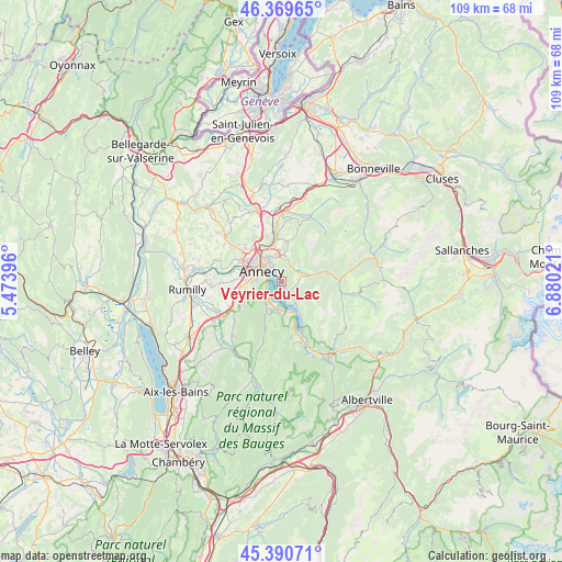
Veyrier-du-Lac GPS coordinates[2]
45° 52' 56.424" North, 6° 10' 37.524" East
| Map corner | latitude | longitude |
|---|---|---|
| Upper-left | 46.36965°, | 5.47396° |
| Center: | 45.88234°, | 6.17709° |
| Lower-right: | 45.39071°, | 6.88021° |
| Map W x H: | 108.8×108.8 km | = 67.6×67.6mi |
| max Lat: | 51.07786° ⇑67.9% North |
| Veyrier-du-Lac: | 45.88234° |
| min Lat: | ⇓32.1% South 41.3874° |
| min Long | Veyrier-du-Lac | max Long |
| -5.08615° | 6.17709° | 9.52242° |
| W 89.1%⇐ | ⇒10.9% E |
Elevation
Elevation of Veyrier-du-Lac is 628 m = 2060 ft, and this is 434.3 m = 1425 ft above average elevation for this country.
| Max E: |
2333 m = 7654 ft | 4.2% |
| Veyrier-du-Lac | 628 m 2060 ft | |
| Avg. | 193.7 m = 635 ft | |
Min E: |
-1 m = -3 ft | 95.8% |
See also: France elevation on elevation.city.
Geographical zone
Veyrier-du-Lac is located in North temperate zone (between Tropic of Cancer and the Arctic Circle). Distance of this North polar circle is 2299.5 km =1428.8 mi to North.| Distance of | km | miles | from Veyrier-du-Lac |
|---|---|---|---|
| North Pole | 4905.4 | 3048.1 | to North |
| Arctic Circle | 2299.5 | 1428.8 | to North |
| Tropic Cancer | 2495.7 | 1550.8 | to South |
| Equator | 5101.6 | 3170 | to South |


Nearby cities:
15 places around Veyrier-du-Lac: (largest is in red/bold)
• Alex
4.6 km =2.9 mi,  79°
79°
• Annecy
4.9 km =3 mi,  306°
306°
• Annecy-le-Vieux
4.9 km =3 mi,  328°
328°
• Cran-Gevrier
6.3 km =3.9 mi,  288°
288°
• Dingy-Saint-Clair
4.6 km =2.9 mi,  54°
54°
• Duingt
6.6 km =4.1 mi,  163°
163°
• Menthon-Saint-Bernard
2.9 km =1.8 mi,  150°
150°
• Metz
7.7 km =4.8 mi,  317°
317°
• Meythet
7.6 km =4.7 mi,  301°
301°
• Nâves-Parmelan
6 km =3.7 mi,  11°
11°
• Saint-Jorioz
5.9 km =3.7 mi,  194°
194°
• Sevrier
3.5 km =2.2 mi,  235°
235°
• Seynod
6.9 km =4.3 mi,  272°
272°
• Talloires
5.4 km =3.4 mi, 148°
• Villaz
7.8 km =4.8 mi, 9°
Sources, notices
• [Note1] Compared only with cities in France existing in our database
• [Src1] Map data: © OpenStreetMap contributors (CC-BY-SA)
• [Src2] Other city data from geonames.org with taken over terms of usage.
• [Src3] Geographical zone / Annual Mean Temperature by Robert A. Rohde @ Wikipedia
