Annecy geodata
Annecy (Auvergne-Rhône-Alpes) is a seat of a second-order administrative division; located in France in Europe/Paris (GMT+2) time zone. With population of 49,232 people, there are 128 cities with bigger population in this country. Compared to other cities in France, 67.5% of cities are located further ↑North; 88.5% of cities are located further ←West and 91.1% of cities have lower elevation than Annecy. Note1
Administrative division(s):
- Level 1: Auvergne-Rhône-Alpes
- Level 2: Haute-Savoie
- Level 3: Annecy
- Level 4: Annecy


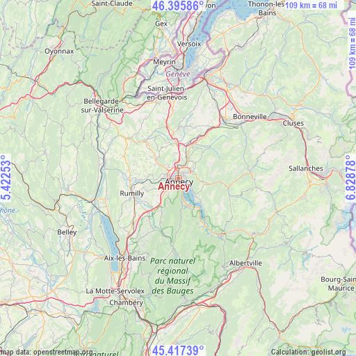
Annecy GPS coordinates[2]
45° 54' 31.608" North, 6° 7' 32.34" East
| Map corner | latitude | longitude |
|---|---|---|
| Upper-left | 46.39586°, | 5.42253° |
| Center: | 45.90878°, | 6.12565° |
| Lower-right: | 45.41739°, | 6.82878° |
| Map W x H: | 108.8×108.8 km | = 67.6×67.6mi |
| max Lat: | 51.07786° ⇑67.5% North |
| Annecy: | 45.90878° |
| min Lat: | ⇓32.5% South 41.3874° |
| min Long | Annecy | max Long |
| -5.08615° | 6.12565° | 9.52242° |
| W 88.5%⇐ | ⇒11.5% E |
Elevation
Elevation of Annecy is 451 m = 1480 ft, and this is 257.3 m = 844 ft above average elevation for this country.
| Max E: |
2333 m = 7654 ft | 8.9% |
| Annecy | 451 m 1480 ft | |
| Avg. | 193.7 m = 635 ft | |
Min E: |
-1 m = -3 ft | 91.1% |
See also: Annecy elevation on elevation.city.
Geographical zone
Annecy is located in North temperate zone (between Tropic of Cancer and the Arctic Circle). Distance of this North polar circle is 2296.6 km =1427 mi to North.| Distance of | km | miles | from Annecy |
|---|---|---|---|
| North Pole | 4902.5 | 3046.3 | to North |
| Arctic Circle | 2296.6 | 1427 | to North |
| Tropic Cancer | 2498.7 | 1552.6 | to South |
| Equator | 5104.6 | 3171.9 | to South |


Nearby cities:
15 places around Annecy: (largest is in red/bold)
• Annecy-le-Vieux
1.9 km =1.2 mi,  49°
49°
• Chavanod
7 km =4.3 mi,  252°
252°
• Cran-Gevrier
2.2 km =1.4 mi,  243°
243°
• Lovagny
7.2 km =4.5 mi,  265°
265°
• Metz
3 km =1.9 mi,  335°
335°
• Meythet
2.7 km =1.7 mi,  293°
293°
• Nâves-Parmelan
5.9 km =3.7 mi,  60°
60°
• Poisy
5 km =3.1 mi, 286°
• Pringy
4.2 km =2.6 mi,  0°
0°
• Saint-Martin-Bellevue
6.5 km =4 mi,  22°
22°
• Sevrier
5.1 km =3.2 mi,  167°
167°
• Seynod
3.9 km =2.4 mi,  228°
228°
• Veyrier-du-Lac
4.9 km =3 mi,  126°
126°
• Villaz
7.1 km =4.4 mi, 48°
• Épagny
4.5 km =2.8 mi,  312°
312°
Sources, notices
• [Note1] Compared only with cities in France existing in our database
• [Src1] Map data: © OpenStreetMap contributors (CC-BY-SA)
• [Src2] Other city data from geonames.org with taken over terms of usage.
• [Src3] Geographical zone / Annual Mean Temperature by Robert A. Rohde @ Wikipedia
