Verneix geodata
Verneix (Auvergne-Rhône-Alpes) is a populated place; located in France in Europe/Paris (GMT+2) time zone. With population of 590 people, there are 13479 cities with bigger population in this country. Compared to other cities in France, 61.1% of cities are located further ↑North; 53% of cities are located further ←West and 86.9% of cities have lower elevation than Verneix. Note1
Administrative division(s):
- Level 1: Auvergne-Rhône-Alpes
- Level 2: Département de l'Allier
- Level 3: Arrondissement de Montluçon
- Level 4: Verneix


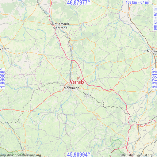
Verneix GPS coordinates[2]
46° 23' 49.236" North, 2° 40' 12.036" East
| Map corner | latitude | longitude |
|---|---|---|
| Upper-left | 46.87977°, | 1.96688° |
| Center: | 46.39701°, | 2.67001° |
| Lower-right: | 45.90994°, | 3.37313° |
| Map W x H: | 107.8×107.8 km | = 67×67mi |
| max Lat: | 51.07786° ⇑61.1% North |
| Verneix: | 46.39701° |
| min Lat: | ⇓38.9% South 41.3874° |
| min Long | Verneix | max Long |
| -5.08615° | 2.67001° | 9.52242° |
| W 53%⇐ | ⇒47% E |
Elevation
Elevation of Verneix is 371 m = 1217 ft, and this is 177.3 m = 582 ft above average elevation for this country.
| Max E: |
2333 m = 7654 ft | 13.1% |
| Verneix | 371 m 1217 ft | |
| Avg. | 193.7 m = 635 ft | |
Min E: |
-1 m = -3 ft | 86.9% |
See also: France elevation on elevation.city.
Geographical zone
Verneix is located in North temperate zone (between Tropic of Cancer and the Arctic Circle). Distance of this North polar circle is 2242.3 km =1393.3 mi to North.| Distance of | km | miles | from Verneix |
|---|---|---|---|
| North Pole | 4848.2 | 3012.5 | to North |
| Arctic Circle | 2242.3 | 1393.3 | to North |
| Tropic Cancer | 2552.9 | 1586.3 | to South |
| Equator | 5158.9 | 3205.6 | to South |


Nearby cities:
15 places around Verneix: (largest is in red/bold)
• Chamblet
7.5 km =4.7 mi,  160°
160°
• Commentry
13.2 km =8.2 mi, 155°
• Domérat
11.2 km =7 mi,  248°
248°
• Doyet
11.9 km =7.4 mi,  124°
124°
• Désertines
6.1 km =3.8 mi,  219°
219°
• Estivareilles
5 km =3.1 mi,  308°
308°
• Hérisson
12.8 km =8 mi,  14°
14°
• La Chapelaude
12.9 km =8 mi,  281°
281°
• Lavault-Sainte-Anne
11.1 km =6.9 mi,  208°
208°
• Malicorne
13.6 km =8.5 mi,  140°
140°
• Montluçon
8.2 km =5.1 mi, 219°
• Néris-les-Bains
12.3 km =7.6 mi,  184°
184°
• Prémilhat
13.9 km =8.6 mi,  227°
227°
• Saint-Victor
4.7 km =2.9 mi,  267°
267°
• Villefranche-d’Allier
14.4 km =8.9 mi,  90°
90°
Sources, notices
• [Note1] Compared only with cities in France existing in our database
• [Src1] Map data: © OpenStreetMap contributors (CC-BY-SA)
• [Src2] Other city data from geonames.org with taken over terms of usage.
• [Src3] Geographical zone / Annual Mean Temperature by Robert A. Rohde @ Wikipedia
