Commentry geodata
Commentry (Auvergne-Rhône-Alpes) is a populated place; located in France in Europe/Paris (GMT+2) time zone. With population of 7,461 people, there are 1307 cities with bigger population in this country. Compared to other cities in France, 62.5% of cities are located further ↑North; 54.1% of cities are located further ←West and 87.5% of cities have lower elevation than Commentry. Note1
Administrative division(s):
- Level 1: Auvergne-Rhône-Alpes
- Level 2: Département de l'Allier
- Level 3: Arrondissement de Montluçon
- Level 4: Commentry


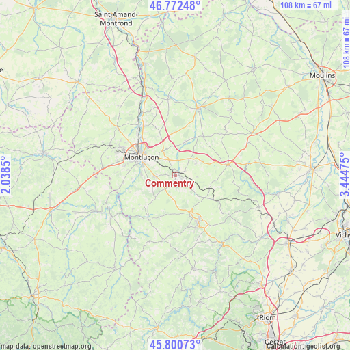
Commentry GPS coordinates[2]
46° 17' 19.536" North, 2° 44' 29.868" East
| Map corner | latitude | longitude |
|---|---|---|
| Upper-left | 46.77248°, | 2.0385° |
| Center: | 46.28876°, | 2.74163° |
| Lower-right: | 45.80073°, | 3.44475° |
| Map W x H: | 108×108 km | = 67.1×67.1mi |
| max Lat: | 51.07786° ⇑62.5% North |
| Commentry: | 46.28876° |
| min Lat: | ⇓37.5% South 41.3874° |
| min Long | Commentry | max Long |
| -5.08615° | 2.74163° | 9.52242° |
| W 54.1%⇐ | ⇒45.9% E |
Elevation
Elevation of Commentry is 381 m = 1250 ft, and this is 187.3 m = 615 ft above average elevation for this country.
| Max E: |
2333 m = 7654 ft | 12.5% |
| Commentry | 381 m 1250 ft | |
| Avg. | 193.7 m = 635 ft | |
Min E: |
-1 m = -3 ft | 87.5% |
See also: France elevation on elevation.city.
Geographical zone
Commentry is located in North temperate zone (between Tropic of Cancer and the Arctic Circle). Distance of this North polar circle is 2254.3 km =1400.8 mi to North.| Distance of | km | miles | from Commentry |
|---|---|---|---|
| North Pole | 4860.2 | 3020 | to North |
| Arctic Circle | 2254.3 | 1400.8 | to North |
| Tropic Cancer | 2540.9 | 1578.8 | to South |
| Equator | 5146.8 | 3198.1 | to South |


Nearby cities:
15 places around Commentry: (largest is in red/bold)
• Bézenet
9.1 km =5.7 mi,  60°
60°
• Chamblet
5.8 km =3.6 mi,  328°
328°
• Doyet
6.7 km =4.2 mi,  39°
39°
• Désertines
11.9 km =7.4 mi,  307°
307°
• Lapeyrouse
12.3 km =7.6 mi,  125°
125°
• Larequille
5.1 km =3.2 mi,  216°
216°
• Lavault-Sainte-Anne
11.1 km =6.9 mi,  282°
282°
• Lignerolles
13.5 km =8.4 mi,  265°
265°
• Malicorne
3.4 km =2.1 mi,  65°
65°
• Montaigut
13.2 km =8.2 mi,  157°
157°
• Montluçon
12.1 km =7.5 mi,  298°
298°
• Montvicq
7 km =4.3 mi, 60°
• Néris-les-Bains
6.4 km =4 mi, 268°
• Verneix
13.2 km =8.2 mi,  335°
335°
• Villebret
8.3 km =5.2 mi,  252°
252°
Sources, notices
• [Note1] Compared only with cities in France existing in our database
• [Src1] Map data: © OpenStreetMap contributors (CC-BY-SA)
• [Src2] Other city data from geonames.org with taken over terms of usage.
• [Src3] Geographical zone / Annual Mean Temperature by Robert A. Rohde @ Wikipedia
