Varilhes geodata
Varilhes (Occitanie) is a populated place; located in France in Europe/Paris (GMT+2) time zone. With population of 2,892 people, there are 3369 cities with bigger population in this country. Compared to other cities in France, 98.2% of cities are located further ↑North; 61.3% of cities are located further →East and 84.3% of cities have lower elevation than Varilhes. Note1
Administrative division(s):
- Level 1: Occitanie
- Level 2: Département de l'Ariège
- Level 3: Arrondissement de Foix
- Level 4: Varilhes


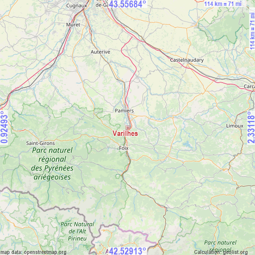
Varilhes GPS coordinates[2]
43° 2' 42.504" North, 1° 37' 40.98" East
| Map corner | latitude | longitude |
|---|---|---|
| Upper-left | 43.55684°, | 0.92493° |
| Center: | 43.04514°, | 1.62805° |
| Lower-right: | 42.52913°, | 2.33118° |
| Map W x H: | 114.3×114.3 km | = 71×71mi |
| max Lat: | 51.07786° ⇑98.2% North |
| Varilhes: | 43.04514° |
| min Lat: | ⇓1.8% South 41.3874° |
| min Long | Varilhes | max Long |
| -5.08615° | 1.62805° | 9.52242° |
| W 38.7%⇐ | ⇒61.3% E |
Elevation
Elevation of Varilhes is 339 m = 1112 ft, and this is 145.3 m = 477 ft above average elevation for this country.
| Max E: |
2333 m = 7654 ft | 15.7% |
| Varilhes | 339 m 1112 ft | |
| Avg. | 193.7 m = 635 ft | |
Min E: |
-1 m = -3 ft | 84.3% |
See also: France elevation on elevation.city.
Geographical zone
Varilhes is located in North temperate zone (between Tropic of Cancer and the Arctic Circle). Distance of this Northern Tropic circle is 2180.3 km =1354.8 mi to South.| Distance of | km | miles | from Varilhes |
|---|---|---|---|
| North Pole | 5220.9 | 3244.1 | to North |
| Arctic Circle | 2615 | 1624.9 | to North |
| Tropic Cancer | 2180.3 | 1354.8 | to South |
| Equator | 4786.2 | 2974 | to South |


Nearby cities:
15 places around Varilhes: (largest is in red/bold)
• Crampagna
2.6 km =1.6 mi,  234°
234°
• Dalou
1.7 km =1.1 mi,  139°
139°
• Ferrières-sur-Ariège
11.7 km =7.3 mi,  185°
185°
• Foix
9.6 km =6 mi, 189°
• Ganac
12.2 km =7.6 mi,  205°
205°
• La Tour-du-Crieu
6.9 km =4.3 mi,  16°
16°
• Les Pujols
8.7 km =5.4 mi,  56°
56°
• Pamiers
8.1 km =5 mi,  349°
349°
• Rieux-de-Pelleport
2.1 km =1.3 mi,  312°
312°
• Saint-Jean-de-Verges
3.8 km =2.4 mi,  201°
201°
• Saint-Jean-du-Falga
4.6 km =2.9 mi,  359°
359°
• Saint-Pierre-de-Rivière
10.9 km =6.8 mi, 212°
• Vernajoul
6.8 km =4.2 mi, 195°
• Verniolle
4.4 km =2.7 mi, 22°
• Villeneuve-du-Paréage
12.2 km =7.6 mi,  3°
3°
Sources, notices
• [Note1] Compared only with cities in France existing in our database
• [Src1] Map data: © OpenStreetMap contributors (CC-BY-SA)
• [Src2] Other city data from geonames.org with taken over terms of usage.
• [Src3] Geographical zone / Annual Mean Temperature by Robert A. Rohde @ Wikipedia
