Pamiers geodata
Pamiers (Occitanie) is a seat of a third-order administrative division; located in France in Europe/Paris (GMT+2) time zone. With population of 16,997 people, there are 557 cities with bigger population in this country. Compared to other cities in France, 97.8% of cities are located further ↑North; 61.6% of cities are located further →East and 81% of cities have lower elevation than Pamiers. Note1
Administrative division(s):
- Level 1: Occitanie
- Level 2: Département de l'Ariège
- Level 3: Arrondissement de Pamiers
- Level 4: Pamiers


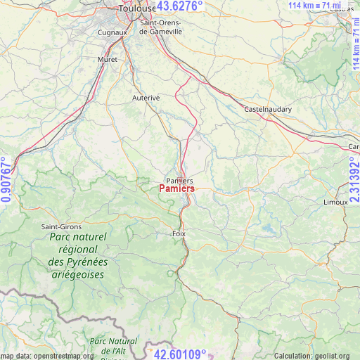
Pamiers GPS coordinates[2]
43° 6' 59.4" North, 1° 36' 38.844" East
| Map corner | latitude | longitude |
|---|---|---|
| Upper-left | 43.6276°, | 0.90767° |
| Center: | 43.1165°, | 1.61079° |
| Lower-right: | 42.60109°, | 2.31392° |
| Map W x H: | 114.1×114.1 km | = 70.9×70.9mi |
| max Lat: | 51.07786° ⇑97.8% North |
| Pamiers: | 43.1165° |
| min Lat: | ⇓2.2% South 41.3874° |
| min Long | Pamiers | max Long |
| -5.08615° | 1.61079° | 9.52242° |
| W 38.4%⇐ | ⇒61.6% E |
Elevation
Elevation of Pamiers is 300 m = 984 ft, and this is 106.3 m = 349 ft above average elevation for this country.
| Max E: |
2333 m = 7654 ft | 19% |
| Pamiers | 300 m 984 ft | |
| Avg. | 193.7 m = 635 ft | |
Min E: |
-1 m = -3 ft | 81% |
See also: France elevation on elevation.city.
Geographical zone
Pamiers is located in North temperate zone (between Tropic of Cancer and the Arctic Circle). Distance of this Northern Tropic circle is 2188.2 km =1359.7 mi to South.| Distance of | km | miles | from Pamiers |
|---|---|---|---|
| North Pole | 5213 | 3239.2 | to North |
| Arctic Circle | 2607.1 | 1620 | to North |
| Tropic Cancer | 2188.2 | 1359.7 | to South |
| Equator | 4794.1 | 2978.9 | to South |


Nearby cities:
15 places around Pamiers: (largest is in red/bold)
• Artigat
14.1 km =8.8 mi,  279°
279°
• Bonnac
5.7 km =3.5 mi,  344°
344°
• Crampagna
9.5 km =5.9 mi,  184°
184°
• Dalou
9.5 km =5.9 mi,  164°
164°
• La Tour-du-Crieu
3.6 km =2.2 mi,  111°
111°
• Le Vernet
7.6 km =4.7 mi,  355°
355°
• Les Pujols
9.3 km =5.8 mi, 110°
• Montaut
8.1 km =5 mi,  23°
23°
• Rieux-de-Pelleport
6.6 km =4.1 mi, 181°
• Saint-Jean-de-Verges
11.4 km =7.1 mi, 180°
• Saint-Jean-du-Falga
3.6 km =2.2 mi, 157°
• Saverdun
13.5 km =8.4 mi,  347°
347°
• Varilhes
8.1 km =5 mi,  169°
169°
• Verniolle
5 km =3.1 mi,  141°
141°
• Villeneuve-du-Paréage
4.7 km =2.9 mi,  27°
27°
Sources, notices
• [Note1] Compared only with cities in France existing in our database
• [Src1] Map data: © OpenStreetMap contributors (CC-BY-SA)
• [Src2] Other city data from geonames.org with taken over terms of usage.
• [Src3] Geographical zone / Annual Mean Temperature by Robert A. Rohde @ Wikipedia
