Ugine geodata
Ugine (Auvergne-Rhône-Alpes) is a populated place; located in France in Europe/Paris (GMT+2) time zone. With population of 7,703 people, there are 1254 cities with bigger population in this country. Compared to other cities in France, 69.9% of cities are located further ↑North; 91.2% of cities are located further ←West and 91.9% of cities have lower elevation than Ugine. Note1
Administrative division(s):
- Level 1: Auvergne-Rhône-Alpes
- Level 2: Savoie
- Level 3: Albertville
- Level 4: Ugine


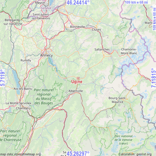
Ugine GPS coordinates[2]
45° 45' 20.556" North, 6° 24' 54.108" East
| Map corner | latitude | longitude |
|---|---|---|
| Upper-left | 46.24414°, | 5.7119° |
| Center: | 45.75571°, | 6.41503° |
| Lower-right: | 45.26297°, | 7.11815° |
| Map W x H: | 109.1×109.1 km | = 67.8×67.8mi |
| max Lat: | 51.07786° ⇑69.9% North |
| Ugine: | 45.75571° |
| min Lat: | ⇓30.1% South 41.3874° |
| min Long | Ugine | max Long |
| -5.08615° | 6.41503° | 9.52242° |
| W 91.2%⇐ | ⇒8.8% E |
Elevation
Elevation of Ugine is 471 m = 1545 ft, and this is 277.3 m = 910 ft above average elevation for this country.
| Max E: |
2333 m = 7654 ft | 8.1% |
| Ugine | 471 m 1545 ft | |
| Avg. | 193.7 m = 635 ft | |
Min E: |
-1 m = -3 ft | 91.9% |
See also: France elevation on elevation.city.
Geographical zone
Ugine is located in North temperate zone (between Tropic of Cancer and the Arctic Circle). Distance of this North polar circle is 2313.6 km =1437.6 mi to North.| Distance of | km | miles | from Ugine |
|---|---|---|---|
| North Pole | 4919.5 | 3056.8 | to North |
| Arctic Circle | 2313.6 | 1437.6 | to North |
| Tropic Cancer | 2481.6 | 1542 | to South |
| Equator | 5087.6 | 3161.3 | to South |


Nearby cities:
15 places around Ugine: (largest is in red/bold)
• Albertville
9.2 km =5.7 mi,  191°
191°
• Faverges
9.6 km =6 mi,  266°
266°
• Flumet
10.4 km =6.5 mi,  47°
47°
• Marlens
5.6 km =3.5 mi,  281°
281°
• Marthod
3.3 km =2.1 mi,  196°
196°
• Mercury
10.9 km =6.8 mi,  213°
213°
• Notre-Dame-de-Bellecombe
9.9 km =6.2 mi, 53°
• Pallud
8.2 km =5.1 mi, 194°
• Queige
5.3 km =3.3 mi,  139°
139°
• Saint-Ferréol
8.3 km =5.2 mi, 276°
• Serraval
7.7 km =4.8 mi,  310°
310°
• Seythenex
9.5 km =5.9 mi,  249°
249°
• Tours-en-Savoie
11.5 km =7.1 mi,  169°
169°
• Venthon
7.7 km =4.8 mi,  183°
183°
• Villard-sur-Doron
10.2 km =6.3 mi,  108°
108°
Sources, notices
• [Note1] Compared only with cities in France existing in our database
• [Src1] Map data: © OpenStreetMap contributors (CC-BY-SA)
• [Src2] Other city data from geonames.org with taken over terms of usage.
• [Src3] Geographical zone / Annual Mean Temperature by Robert A. Rohde @ Wikipedia
