Seythenex geodata
Seythenex (Auvergne-Rhône-Alpes) is a populated place; located in France in Europe/Paris (GMT+2) time zone. With population of 549 people, there are 14229 cities with bigger population in this country. Compared to other cities in France, 70.4% of cities are located further ↑North; 90.1% of cities are located further ←West and 97.2% of cities have lower elevation than Seythenex. Note1
Administrative division(s):
- Level 1: Auvergne-Rhône-Alpes
- Level 2: Haute-Savoie
- Level 3: Annecy
- Level 4: Faverges-Seythenex


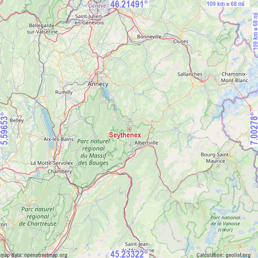
Seythenex GPS coordinates[2]
45° 43' 34.392" North, 6° 17' 58.74" East
| Map corner | latitude | longitude |
|---|---|---|
| Upper-left | 46.21491°, | 5.59653° |
| Center: | 45.72622°, | 6.29965° |
| Lower-right: | 45.23322°, | 7.00278° |
| Map W x H: | 109.2×109.2 km | = 67.9×67.9mi |
| max Lat: | 51.07786° ⇑70.4% North |
| Seythenex: | 45.72622° |
| min Lat: | ⇓29.6% South 41.3874° |
| min Long | Seythenex | max Long |
| -5.08615° | 6.29965° | 9.52242° |
| W 90.1%⇐ | ⇒9.9% E |
Elevation
Elevation of Seythenex is 741 m = 2431 ft, and this is 547.3 m = 1796 ft above average elevation for this country.
| Max E: |
2333 m = 7654 ft | 2.8% |
| Seythenex | 741 m 2431 ft | |
| Avg. | 193.7 m = 635 ft | |
Min E: |
-1 m = -3 ft | 97.2% |
See also: France elevation on elevation.city.
Geographical zone
Seythenex is located in North temperate zone (between Tropic of Cancer and the Arctic Circle). Distance of this North polar circle is 2316.9 km =1439.7 mi to North.| Distance of | km | miles | from Seythenex |
|---|---|---|---|
| North Pole | 4922.8 | 3058.9 | to North |
| Arctic Circle | 2316.9 | 1439.7 | to North |
| Tropic Cancer | 2478.4 | 1540 | to South |
| Equator | 5084.3 | 3159.2 | to South |


Nearby cities:
15 places around Seythenex: (largest is in red/bold)
• Albertville
9.1 km =5.7 mi,  129°
129°
• Doussard
7.9 km =4.9 mi,  313°
313°
• Faverges
2.8 km =1.7 mi,  347°
347°
• Gilly-sur-Isère
8.5 km =5.3 mi,  151°
151°
• Grignon
10.3 km =6.4 mi,  143°
143°
• Lathuile
9.8 km =6.1 mi, 311°
• Marlens
5.6 km =3.5 mi,  38°
38°
• Marthod
8 km =5 mi,  89°
89°
• Mercury
6.4 km =4 mi, 153°
• Pallud
8.3 km =5.2 mi,  123°
123°
• Saint-Ferréol
4.3 km =2.7 mi,  9°
9°
• Serraval
8.9 km =5.5 mi,  20°
20°
• Ugine
9.5 km =5.9 mi,  69°
69°
• Venthon
9.6 km =6 mi, 117°
• Verrens
8 km =5 mi,  169°
169°
Sources, notices
• [Note1] Compared only with cities in France existing in our database
• [Src1] Map data: © OpenStreetMap contributors (CC-BY-SA)
• [Src2] Other city data from geonames.org with taken over terms of usage.
• [Src3] Geographical zone / Annual Mean Temperature by Robert A. Rohde @ Wikipedia
