Marlens geodata
Marlens (Auvergne-Rhône-Alpes) is a populated place; located in France in Europe/Paris (GMT+2) time zone. With population of 775 people, there are 10884 cities with bigger population in this country. Compared to other cities in France, 69.8% of cities are located further ↑North; 90.6% of cities are located further ←West and 93% of cities have lower elevation than Marlens. Note1
Administrative division(s):
- Level 1: Auvergne-Rhône-Alpes
- Level 2: Haute-Savoie
- Level 3: Annecy
- Level 4: Val de Chaise


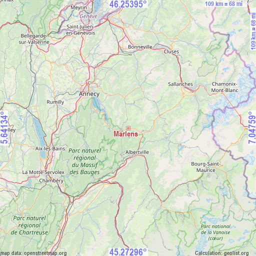
Marlens GPS coordinates[2]
45° 45' 56.196" North, 6° 20' 40.056" East
| Map corner | latitude | longitude |
|---|---|---|
| Upper-left | 46.25395°, | 5.64134° |
| Center: | 45.76561°, | 6.34446° |
| Lower-right: | 45.27296°, | 7.04759° |
| Map W x H: | 109.1×109.1 km | = 67.8×67.8mi |
| max Lat: | 51.07786° ⇑69.8% North |
| Marlens: | 45.76561° |
| min Lat: | ⇓30.2% South 41.3874° |
| min Long | Marlens | max Long |
| -5.08615° | 6.34446° | 9.52242° |
| W 90.6%⇐ | ⇒9.4% E |
Elevation
Elevation of Marlens is 504 m = 1654 ft, and this is 310.3 m = 1018 ft above average elevation for this country.
| Max E: |
2333 m = 7654 ft | 7% |
| Marlens | 504 m 1654 ft | |
| Avg. | 193.7 m = 635 ft | |
Min E: |
-1 m = -3 ft | 93% |
See also: France elevation on elevation.city.
Geographical zone
Marlens is located in North temperate zone (between Tropic of Cancer and the Arctic Circle). Distance of this North polar circle is 2312.5 km =1436.9 mi to North.| Distance of | km | miles | from Marlens |
|---|---|---|---|
| North Pole | 4918.4 | 3056.2 | to North |
| Arctic Circle | 2312.5 | 1436.9 | to North |
| Tropic Cancer | 2482.7 | 1542.7 | to South |
| Equator | 5088.7 | 3162 | to South |


Nearby cities:
15 places around Marlens: (largest is in red/bold)
• Albertville
10.7 km =6.6 mi,  160°
160°
• Doussard
9.3 km =5.8 mi,  276°
276°
• Faverges
4.4 km =2.7 mi,  248°
248°
• Lathuile
11.1 km =6.9 mi, 280°
• Les Clefs
10.7 km =6.6 mi,  353°
353°
• Manigod
11 km =6.8 mi,  12°
12°
• Marthod
6.2 km =3.9 mi,  133°
133°
• Mercury
10.1 km =6.3 mi,  183°
183°
• Pallud
9.7 km =6 mi, 159°
• Queige
10.3 km =6.4 mi,  119°
119°
• Saint-Ferréol
2.8 km =1.7 mi,  267°
267°
• Serraval
3.9 km =2.4 mi,  355°
355°
• Seythenex
5.6 km =3.5 mi,  218°
218°
• Ugine
5.6 km =3.5 mi,  101°
101°
• Venthon
10.1 km =6.3 mi,  150°
150°
Sources, notices
• [Note1] Compared only with cities in France existing in our database
• [Src1] Map data: © OpenStreetMap contributors (CC-BY-SA)
• [Src2] Other city data from geonames.org with taken over terms of usage.
• [Src3] Geographical zone / Annual Mean Temperature by Robert A. Rohde @ Wikipedia
