Tresserve geodata
Tresserve (Auvergne-Rhône-Alpes) is a populated place; located in France in Europe/Paris (GMT+2) time zone. With population of 3,303 people, there are 2953 cities with bigger population in this country. Compared to other cities in France, 71.3% of cities are located further ↑North; 85.9% of cities are located further ←West and 76.1% of cities have lower elevation than Tresserve. Note1
Administrative division(s):
- Level 1: Auvergne-Rhône-Alpes
- Level 2: Savoie
- Level 3: Arrondissement de Chambéry
- Level 4: Tresserve


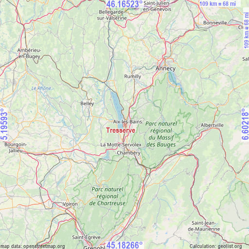
Tresserve GPS coordinates[2]
45° 40' 33.96" North, 5° 53' 56.616" East
| Map corner | latitude | longitude |
|---|---|---|
| Upper-left | 46.16523°, | 5.19593° |
| Center: | 45.6761°, | 5.89906° |
| Lower-right: | 45.18266°, | 6.60218° |
| Map W x H: | 109.3×109.2 km | = 67.9×67.9mi |
| max Lat: | 51.07786° ⇑71.3% North |
| Tresserve: | 45.6761° |
| min Lat: | ⇓28.7% South 41.3874° |
| min Long | Tresserve | max Long |
| -5.08615° | 5.89906° | 9.52242° |
| W 85.9%⇐ | ⇒14.1% E |
Elevation
Elevation of Tresserve is 257 m = 843 ft, and this is 63.3 m = 208 ft above average elevation for this country.
| Max E: |
2333 m = 7654 ft | 23.9% |
| Tresserve | 257 m 843 ft | |
| Avg. | 193.7 m = 635 ft | |
Min E: |
-1 m = -3 ft | 76.1% |
See also: France elevation on elevation.city.
Geographical zone
Tresserve is located in North temperate zone (between Tropic of Cancer and the Arctic Circle). Distance of this North polar circle is 2322.5 km =1443.1 mi to North.| Distance of | km | miles | from Tresserve |
|---|---|---|---|
| North Pole | 4928.4 | 3062.4 | to North |
| Arctic Circle | 2322.5 | 1443.1 | to North |
| Tropic Cancer | 2472.8 | 1536.5 | to South |
| Equator | 5078.7 | 3155.8 | to South |


Nearby cities:
15 places around Tresserve: (largest is in red/bold)
• Aix-les-Bains
1.9 km =1.2 mi,  23°
23°
• Brison-Saint-Innocent
5.4 km =3.4 mi,  351°
351°
• Drumettaz
2.4 km =1.5 mi,  132°
132°
• Grésy-sur-Aix
5.6 km =3.5 mi, 21°
• La Motte-Servolex
9.1 km =5.7 mi,  195°
195°
• Le Bourget-du-Lac
4.2 km =2.6 mi,  233°
233°
• Montcel
8.5 km =5.3 mi,  50°
50°
• Mouxy
3 km =1.9 mi,  72°
72°
• Méry
4.8 km =3 mi,  143°
143°
• Pugny-Chatenod
4.6 km =2.9 mi,  55°
55°
• Saint-Jean-de-Chevelu
5.8 km =3.6 mi,  293°
293°
• Sonnaz
6.6 km =4.1 mi,  169°
169°
• Trévignin
5.5 km =3.4 mi, 52°
• Viviers-du-Lac
2.9 km =1.8 mi,  178°
178°
• Voglans
6.4 km =4 mi,  187°
187°
Sources, notices
• [Note1] Compared only with cities in France existing in our database
• [Src1] Map data: © OpenStreetMap contributors (CC-BY-SA)
• [Src2] Other city data from geonames.org with taken over terms of usage.
• [Src3] Geographical zone / Annual Mean Temperature by Robert A. Rohde @ Wikipedia
