La Motte-Servolex geodata
La Motte-Servolex (Auvergne-Rhône-Alpes) is a populated place; located in France in Europe/Paris (GMT+2) time zone. With population of 13,499 people, there are 705 cities with bigger population in this country. Compared to other cities in France, 72.6% of cities are located further ↑North; 85.7% of cities are located further ←West and 76.9% of cities have lower elevation than La Motte-Servolex. Note1
Administrative division(s):
- Level 1: Auvergne-Rhône-Alpes
- Level 2: Savoie
- Level 3: Arrondissement de Chambéry
- Level 4: La Motte-Servolex


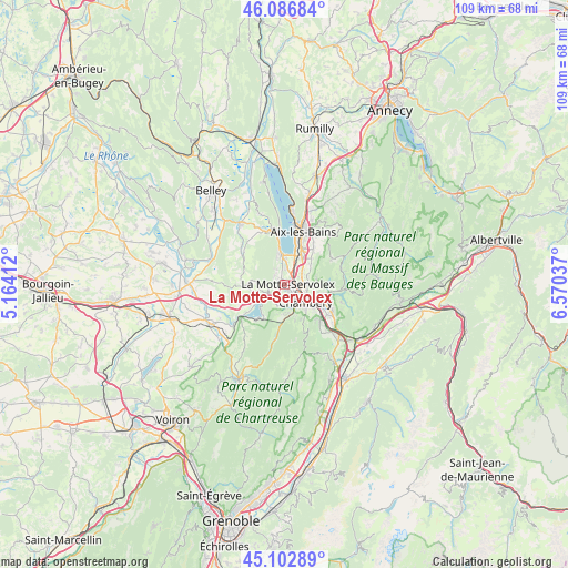
La Motte-Servolex GPS coordinates[2]
45° 35' 49.272" North, 5° 52' 2.064" East
| Map corner | latitude | longitude |
|---|---|---|
| Upper-left | 46.08684°, | 5.16412° |
| Center: | 45.59702°, | 5.86724° |
| Lower-right: | 45.10289°, | 6.57037° |
| Map W x H: | 109.4×109.4 km | = 68×68mi |
| max Lat: | 51.07786° ⇑72.6% North |
| La Motte-Servolex: | 45.59702° |
| min Lat: | ⇓27.4% South 41.3874° |
| min Long | La Motte-Servol | max Long |
| -5.08615° | 5.86724° | 9.52242° |
| W 85.7%⇐ | ⇒14.3% E |
Elevation
Elevation of La Motte-Servolex is 263 m = 863 ft, and this is 69.3 m = 227 ft above average elevation for this country.
| Max E: |
2333 m = 7654 ft | 23.1% |
| La Motte-Servolex | 263 m 863 ft | |
| Avg. | 193.7 m = 635 ft | |
Min E: |
-1 m = -3 ft | 76.9% |
See also: France elevation on elevation.city.
Geographical zone
La Motte-Servolex is located in North temperate zone (between Tropic of Cancer and the Arctic Circle). Distance of this North polar circle is 2331.3 km =1448.6 mi to North.| Distance of | km | miles | from La Motte-Servolex |
|---|---|---|---|
| North Pole | 4937.1 | 3067.8 | to North |
| Arctic Circle | 2331.3 | 1448.6 | to North |
| Tropic Cancer | 2464 | 1531.1 | to South |
| Equator | 5069.9 | 3150.3 | to South |


Nearby cities:
15 places around La Motte-Servolex: (largest is in red/bold)
• Barberaz
7.1 km =4.4 mi,  123°
123°
• Bassens
6.1 km =3.8 mi,  113°
113°
• Chambéry
5.4 km =3.4 mi,  129°
129°
• Cognin
4.6 km =2.9 mi,  155°
155°
• Jacob-Bellecombette
5.7 km =3.5 mi,  139°
139°
• Le Bourget-du-Lac
6.4 km =4 mi,  351°
351°
• Montagnole
7.2 km =4.5 mi,  150°
150°
• Méry
7.2 km =4.5 mi,  47°
47°
• Novalaise
7 km =4.3 mi,  267°
267°
• Saint-Alban-Leysse
6.6 km =4.1 mi,  103°
103°
• Saint-Sulpice
3.7 km =2.3 mi,  207°
207°
• Sonnaz
4.4 km =2.7 mi,  58°
58°
• Vimines
5.6 km =3.5 mi,  181°
181°
• Viviers-du-Lac
6.4 km =4 mi,  23°
23°
• Voglans
2.9 km =1.8 mi,  33°
33°
Sources, notices
• [Note1] Compared only with cities in France existing in our database
• [Src1] Map data: © OpenStreetMap contributors (CC-BY-SA)
• [Src2] Other city data from geonames.org with taken over terms of usage.
• [Src3] Geographical zone / Annual Mean Temperature by Robert A. Rohde @ Wikipedia
