Méry geodata
Méry (Auvergne-Rhône-Alpes) is a populated place; located in France in Europe/Paris (GMT+2) time zone. With population of 1,276 people, there are 7143 cities with bigger population in this country. Compared to other cities in France, 71.9% of cities are located further ↑North; 86.4% of cities are located further ←West and 93.8% of cities have lower elevation than Méry. Note1
Administrative division(s):
- Level 1: Auvergne-Rhône-Alpes
- Level 2: Savoie
- Level 3: Arrondissement de Chambéry
- Level 4: Méry


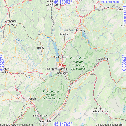
Méry GPS coordinates[2]
45° 38' 29.004" North, 5° 56' 7.8" East
| Map corner | latitude | longitude |
|---|---|---|
| Upper-left | 46.13082°, | 5.23237° |
| Center: | 45.64139°, | 5.9355° |
| Lower-right: | 45.14765°, | 6.63862° |
| Map W x H: | 109.3×109.3 km | = 67.9×67.9mi |
| max Lat: | 51.07786° ⇑71.9% North |
| Méry: | 45.64139° |
| min Lat: | ⇓28.1% South 41.3874° |
| min Long | Méry | max Long |
| -5.08615° | 5.9355° | 9.52242° |
| W 86.4%⇐ | ⇒13.6% E |
Elevation
Elevation of Méry is 534 m = 1752 ft, and this is 340.3 m = 1116 ft above average elevation for this country.
| Max E: |
2333 m = 7654 ft | 6.2% |
| Méry | 534 m 1752 ft | |
| Avg. | 193.7 m = 635 ft | |
Min E: |
-1 m = -3 ft | 93.8% |
See also: France elevation on elevation.city.
Geographical zone
Méry is located in North temperate zone (between Tropic of Cancer and the Arctic Circle). Distance of this North polar circle is 2326.3 km =1445.5 mi to North.| Distance of | km | miles | from Méry |
|---|---|---|---|
| North Pole | 4932.2 | 3064.7 | to North |
| Arctic Circle | 2326.3 | 1445.5 | to North |
| Tropic Cancer | 2468.9 | 1534.1 | to South |
| Equator | 5074.8 | 3153.3 | to South |


Nearby cities:
15 places around Méry: (largest is in red/bold)
• Aix-les-Bains
6 km =3.7 mi,  339°
339°
• Barby
8.8 km =5.5 mi,  157°
157°
• Bassens
7.3 km =4.5 mi,  177°
177°
• Chambéry
8.4 km =5.2 mi,  187°
187°
• Drumettaz
2.5 km =1.6 mi,  334°
334°
• La Motte-Servolex
7.2 km =4.5 mi,  227°
227°
• Le Bourget-du-Lac
6.4 km =4 mi,  282°
282°
• Mouxy
4.7 km =2.9 mi,  359°
359°
• Pugny-Chatenod
6.5 km =4 mi,  8°
8°
• Saint-Alban-Leysse
6.6 km =4.1 mi,  170°
170°
• Sonnaz
3.1 km =1.9 mi,  211°
211°
• Tresserve
4.8 km =3 mi,  323°
323°
• Trévignin
7.4 km =4.6 mi, 11°
• Viviers-du-Lac
2.9 km =1.8 mi,  289°
289°
• Voglans
4.5 km =2.8 mi,  235°
235°
Sources, notices
• [Note1] Compared only with cities in France existing in our database
• [Src1] Map data: © OpenStreetMap contributors (CC-BY-SA)
• [Src2] Other city data from geonames.org with taken over terms of usage.
• [Src3] Geographical zone / Annual Mean Temperature by Robert A. Rohde @ Wikipedia
