Tramoyes geodata
Tramoyes (Auvergne-Rhône-Alpes) is a populated place; located in France in Europe/Paris (GMT+2) time zone. With population of 1,663 people, there are 5629 cities with bigger population in this country. Compared to other cities in France, 68.1% of cities are located further ↑North; 77.3% of cities are located further ←West and 81% of cities have lower elevation than Tramoyes. Note1
Administrative division(s):
- Level 1: Auvergne-Rhône-Alpes
- Level 2: Département de l'Ain
- Level 3: Arrondissement de Bourg-en-Bresse
- Level 4: Tramoyes


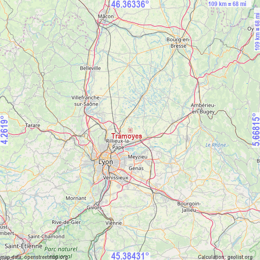
Tramoyes GPS coordinates[2]
45° 52' 33.564" North, 4° 57' 54.072" East
| Map corner | latitude | longitude |
|---|---|---|
| Upper-left | 46.36336°, | 4.2619° |
| Center: | 45.87599°, | 4.96502° |
| Lower-right: | 45.38431°, | 5.66815° |
| Map W x H: | 108.9×108.9 km | = 67.7×67.7mi |
| max Lat: | 51.07786° ⇑68.1% North |
| Tramoyes: | 45.87599° |
| min Lat: | ⇓31.9% South 41.3874° |
| min Long | Tramoyes | max Long |
| -5.08615° | 4.96502° | 9.52242° |
| W 77.3%⇐ | ⇒22.7% E |
Elevation
Elevation of Tramoyes is 300 m = 984 ft, and this is 106.3 m = 349 ft above average elevation for this country.
| Max E: |
2333 m = 7654 ft | 19% |
| Tramoyes | 300 m 984 ft | |
| Avg. | 193.7 m = 635 ft | |
Min E: |
-1 m = -3 ft | 81% |
See also: France elevation on elevation.city.
Geographical zone
Tramoyes is located in North temperate zone (between Tropic of Cancer and the Arctic Circle). Distance of this North polar circle is 2300.2 km =1429.3 mi to North.| Distance of | km | miles | from Tramoyes |
|---|---|---|---|
| North Pole | 4906.1 | 3048.5 | to North |
| Arctic Circle | 2300.2 | 1429.3 | to North |
| Tropic Cancer | 2495 | 1550.3 | to South |
| Equator | 5100.9 | 3169.6 | to South |


Nearby cities:
15 places around Tramoyes: (largest is in red/bold)
• Beynost
5.2 km =3.2 mi,  149°
149°
• Cailloux-sur-Fontaines
7.5 km =4.7 mi,  249°
249°
• Civrieux
8.1 km =5 mi,  307°
307°
• La Boisse
6.6 km =4.1 mi,  123°
123°
• Mionnay
3.8 km =2.4 mi, 310°
• Miribel
5.6 km =3.5 mi,  188°
188°
• Montanay
7.9 km =4.9 mi,  272°
272°
• Montluel
7.7 km =4.8 mi,  110°
110°
• Rillieux-la-Pape
8.3 km =5.2 mi,  217°
217°
• Saint-André-de-Corcy
5.6 km =3.5 mi,  349°
349°
• Saint-Maurice-de-Beynost
4.7 km =2.9 mi,  168°
168°
• Sainte-Croix
7.1 km =4.4 mi,  73°
73°
• Sathonay-Camp
9 km =5.6 mi,  230°
230°
• Sathonay-Village
8.2 km =5.1 mi, 234°
• Thil
8.3 km =5.2 mi, 146°
Sources, notices
• [Note1] Compared only with cities in France existing in our database
• [Src1] Map data: © OpenStreetMap contributors (CC-BY-SA)
• [Src2] Other city data from geonames.org with taken over terms of usage.
• [Src3] Geographical zone / Annual Mean Temperature by Robert A. Rohde @ Wikipedia
