Sathonay-Village geodata
Sathonay-Village (Auvergne-Rhône-Alpes) is a populated place; located in France in Europe/Paris (GMT+2) time zone. With population of 1,786 people, there are 5315 cities with bigger population in this country. Compared to other cities in France, 68.8% of cities are located further ↑North; 76.2% of cities are located further ←West and 80.2% of cities have lower elevation than Sathonay-Village. Note1
Administrative division(s):
- Level 1: Auvergne-Rhône-Alpes
- Level 2: Département du Rhône
- Level 3: Arrondissement de Lyon
- Level 4: Sathonay-Village


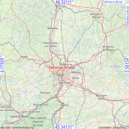
Sathonay-Village GPS coordinates[2]
45° 50' 0.132" North, 4° 52' 41.556" East
| Map corner | latitude | longitude |
|---|---|---|
| Upper-left | 46.32111°, | 4.17509° |
| Center: | 45.83337°, | 4.87821° |
| Lower-right: | 45.34131°, | 5.58134° |
| Map W x H: | 108.9×108.9 km | = 67.7×67.7mi |
| max Lat: | 51.07786° ⇑68.8% North |
| Sathonay-Village: | 45.83337° |
| min Lat: | ⇓31.2% South 41.3874° |
| min Long | Sathonay-Villag | max Long |
| -5.08615° | 4.87821° | 9.52242° |
| W 76.2%⇐ | ⇒23.8% E |
Elevation
Elevation of Sathonay-Village is 292 m = 958 ft, and this is 98.3 m = 323 ft above average elevation for this country.
| Max E: |
2333 m = 7654 ft | 19.8% |
| Sathonay-Village | 292 m 958 ft | |
| Avg. | 193.7 m = 635 ft | |
Min E: |
-1 m = -3 ft | 80.2% |
See also: France elevation on elevation.city.
Geographical zone
Sathonay-Village is located in North temperate zone (between Tropic of Cancer and the Arctic Circle). Distance of this North polar circle is 2305 km =1432.3 mi to North.| Distance of | km | miles | from Sathonay-Village |
|---|---|---|---|
| North Pole | 4910.9 | 3051.5 | to North |
| Arctic Circle | 2305 | 1432.3 | to North |
| Tropic Cancer | 2490.3 | 1547.4 | to South |
| Equator | 5096.2 | 3166.6 | to South |


Nearby cities:
15 places around Sathonay-Village: (largest is in red/bold)
• Albigny-sur-Saône
5.1 km =3.2 mi,  316°
316°
• Cailloux-sur-Fontaines
2.2 km =1.4 mi,  352°
352°
• Caluire-et-Cuire
5 km =3.1 mi,  209°
209°
• Couzon-au-Mont-d’Or
4 km =2.5 mi,  287°
287°
• Fleurieu-sur-Saône
3.9 km =2.4 mi, 321°
• Fontaines-Saint-Martin
2.3 km =1.4 mi,  301°
301°
• Fontaines-sur-Saône
2.6 km =1.6 mi,  275°
275°
• Miribel
6 km =3.7 mi,  98°
98°
• Montanay
5.2 km =3.2 mi, 347°
• Neuville-sur-Saône
5.6 km =3.5 mi,  328°
328°
• Rillieux-la-Pape
2.5 km =1.6 mi,  137°
137°
• Rochetaillée-sur-Saône
2.9 km =1.8 mi,  310°
310°
• Sathonay-Camp
1 km =0.6 mi,  196°
196°
• Vaulx-en-Velin
6.3 km =3.9 mi, 144°
• Villeurbanne
7.5 km =4.7 mi,  179°
179°
Sources, notices
• [Note1] Compared only with cities in France existing in our database
• [Src1] Map data: © OpenStreetMap contributors (CC-BY-SA)
• [Src2] Other city data from geonames.org with taken over terms of usage.
• [Src3] Geographical zone / Annual Mean Temperature by Robert A. Rohde @ Wikipedia
