Touvre geodata
Touvre (Nouvelle-Aquitaine) is a populated place; located in France in Europe/Paris (GMT+2) time zone. With population of 1,073 people, there are 8312 cities with bigger population in this country. Compared to other cities in France, 71.5% of cities are located further ↑North; 75.8% of cities are located further →East and 81.5% of cities have higher elevation than Touvre. Note1
Administrative division(s):
- Level 1: Nouvelle-Aquitaine
- Level 2: Charente
- Level 3: Arrondissement d’Angoulême
- Level 4: Touvre


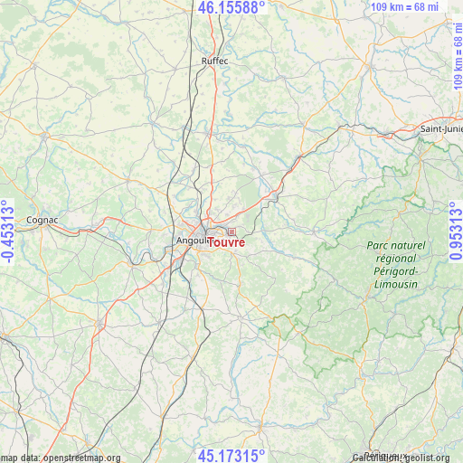
Touvre GPS coordinates[2]
45° 40' 0.012" North, 0° 15' 0" East
| Map corner | latitude | longitude |
|---|---|---|
| Upper-left | 46.15588°, | -0.45313° |
| Center: | 45.66667°, | 0.25° |
| Lower-right: | 45.17315°, | 0.95313° |
| Map W x H: | 109.3×109.3 km | = 67.9×67.9mi |
| max Lat: | 51.07786° ⇑71.5% North |
| Touvre: | 45.66667° |
| min Lat: | ⇓28.5% South 41.3874° |
| min Long | Touvre | max Long |
| -5.08615° | 0.25° | 9.52242° |
| W 24.2%⇐ | ⇒75.8% E |
Elevation
Elevation of Touvre is 51 m = 167 ft, and this is 142.7 m = 468 ft below average elevation for this country.
| Max E: |
2333 m = 7654 ft | 81.5% |
| Avg. | 193.7 m = 635 ft | |
| Touvre | 51 m = 167 ft | |
Min E: |
-1 m = -3 ft | 18.5% |
See also: France elevation on elevation.city.
Geographical zone
Touvre is located in North temperate zone (between Tropic of Cancer and the Arctic Circle). Distance of this North polar circle is 2323.5 km =1443.8 mi to North.| Distance of | km | miles | from Touvre |
|---|---|---|---|
| North Pole | 4929.4 | 3063 | to North |
| Arctic Circle | 2323.5 | 1443.8 | to North |
| Tropic Cancer | 2471.7 | 1535.8 | to South |
| Equator | 5077.7 | 3155.1 | to South |


Nearby cities:
15 places around Touvre: (largest is in red/bold)
• Angoulême
8 km =5 mi,  256°
256°
• Bouëx
7.6 km =4.7 mi,  137°
137°
• Brie
8 km =5 mi,  355°
355°
• Champniers
6.4 km =4 mi,  326°
326°
• Chazelles
9.4 km =5.8 mi,  103°
103°
• Dirac
7.4 km =4.6 mi,  180°
180°
• Garat
3.9 km =2.4 mi,  160°
160°
• Gond-Pontouvre
6.7 km =4.2 mi,  285°
285°
• Magnac-sur-Touvre
1.3 km =0.8 mi,  270°
270°
• Mornac
2.3 km =1.4 mi,  34°
34°
• Pranzac
7.8 km =4.8 mi,  90°
90°
• Puymoyen
7.6 km =4.7 mi,  222°
222°
• Ruelle-sur-Touvre
2.3 km =1.4 mi, 325°
• Sers
9 km =5.6 mi,  145°
145°
• Soyaux
4.3 km =2.7 mi,  244°
244°
Sources, notices
• [Note1] Compared only with cities in France existing in our database
• [Src1] Map data: © OpenStreetMap contributors (CC-BY-SA)
• [Src2] Other city data from geonames.org with taken over terms of usage.
• [Src3] Geographical zone / Annual Mean Temperature by Robert A. Rohde @ Wikipedia
