Chazelles geodata
Chazelles (Nouvelle-Aquitaine) is a populated place; located in France in Europe/Paris (GMT+2) time zone. With population of 1,440 people, there are 6430 cities with bigger population in this country. Compared to other cities in France, 71.8% of cities are located further ↑North; 74.6% of cities are located further →East and 62.4% of cities have higher elevation than Chazelles. Note1
Administrative division(s):
- Level 1: Nouvelle-Aquitaine
- Level 2: Charente
- Level 3: Arrondissement d’Angoulême
- Level 4: Chazelles


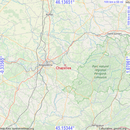
Chazelles GPS coordinates[2]
45° 38' 49.668" North, 0° 22' 2.928" East
| Map corner | latitude | longitude |
|---|---|---|
| Upper-left | 46.13651°, | -0.33565° |
| Center: | 45.64713°, | 0.36748° |
| Lower-right: | 45.15344°, | 1.07061° |
| Map W x H: | 109.3×109.3 km | = 67.9×67.9mi |
| max Lat: | 51.07786° ⇑71.8% North |
| Chazelles: | 45.64713° |
| min Lat: | ⇓28.2% South 41.3874° |
| min Long | Chazelles | max Long |
| -5.08615° | 0.36748° | 9.52242° |
| W 25.4%⇐ | ⇒74.6% E |
Elevation
Elevation of Chazelles is 96 m = 315 ft, and this is 97.7 m = 321 ft below average elevation for this country.
| Max E: |
2333 m = 7654 ft | 62.4% |
| Avg. | 193.7 m = 635 ft | |
| Chazelles | 96 m = 315 ft | |
Min E: |
-1 m = -3 ft | 37.6% |
See also: France elevation on elevation.city.
Geographical zone
Chazelles is located in North temperate zone (between Tropic of Cancer and the Arctic Circle). Distance of this North polar circle is 2325.7 km =1445.1 mi to North.| Distance of | km | miles | from Chazelles |
|---|---|---|---|
| North Pole | 4931.6 | 3064.4 | to North |
| Arctic Circle | 2325.7 | 1445.1 | to North |
| Tropic Cancer | 2469.6 | 1534.5 | to South |
| Equator | 5075.5 | 3153.8 | to South |


Nearby cities:
15 places around Chazelles: (largest is in red/bold)
• Bouëx
5.2 km =3.2 mi,  229°
229°
• Dirac
10.5 km =6.5 mi,  240°
240°
• Garat
8 km =5 mi,  258°
258°
• La Rochefoucauld
10.5 km =6.5 mi,  7°
7°
• Magnac-sur-Touvre
10.6 km =6.6 mi,  281°
281°
• Marillac-le-Franc
10.9 km =6.8 mi,  28°
28°
• Marthon
6.9 km =4.3 mi,  121°
121°
• Montbron
10.5 km =6.5 mi,  78°
78°
• Mornac
8.8 km =5.5 mi,  297°
297°
• Pranzac
2.6 km =1.6 mi,  327°
327°
• Saint-Projet-Saint-Constant
9.3 km =5.8 mi,  345°
345°
• Saint-Sornin
7.4 km =4.6 mi,  46°
46°
• Sers
6.6 km =4.1 mi,  217°
217°
• Touvre
9.4 km =5.8 mi, 283°
• Vouzan
5.4 km =3.4 mi,  194°
194°
Sources, notices
• [Note1] Compared only with cities in France existing in our database
• [Src1] Map data: © OpenStreetMap contributors (CC-BY-SA)
• [Src2] Other city data from geonames.org with taken over terms of usage.
• [Src3] Geographical zone / Annual Mean Temperature by Robert A. Rohde @ Wikipedia
