Toul geodata
Toul (Grand Est) is a seat of a third-order administrative division; located in France in Europe/Paris (GMT+2) time zone. With population of 17,680 people, there are 538 cities with bigger population in this country. Compared to other cities in France, 72.8% of cities are located further ↓South; 85.9% of cities are located further ←West and 67.4% of cities have lower elevation than Toul. Note1
Administrative division(s):
- Level 1: Grand Est
- Level 2: Meurthe-et-Moselle
- Level 3: Arrondissement de Toul
- Level 4: Toul


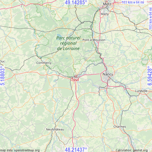
Toul GPS coordinates[2]
48° 40' 50.7" North, 5° 53' 28.14" East
| Map corner | latitude | longitude |
|---|---|---|
| Upper-left | 49.14285°, | 5.18803° |
| Center: | 48.68075°, | 5.89115° |
| Lower-right: | 48.21437°, | 6.59428° |
| Map W x H: | 103.2×103.2 km | = 64.1×64.1mi |
| max Lat: | 51.07786° ⇑27.2% North |
| Toul: | 48.68075° |
| min Lat: | ⇓72.8% South 41.3874° |
| min Long | Toul | max Long |
| -5.08615° | 5.89115° | 9.52242° |
| W 85.9%⇐ | ⇒14.1% E |
Elevation
Elevation of Toul is 206 m = 676 ft, and this is 12.3 m = 40 ft above average elevation for this country.
| Max E: |
2333 m = 7654 ft | 32.6% |
| Toul | 206 m 676 ft | |
| Avg. | 193.7 m = 635 ft | |
Min E: |
-1 m = -3 ft | 67.4% |
See also: France elevation on elevation.city.
Geographical zone
Toul is located in North temperate zone (between Tropic of Cancer and the Arctic Circle). Distance of this North polar circle is 1988.4 km =1235.5 mi to North.| Distance of | km | miles | from Toul |
|---|---|---|---|
| North Pole | 4594.3 | 2854.8 | to North |
| Arctic Circle | 1988.4 | 1235.5 | to North |
| Tropic Cancer | 2806.9 | 1744.1 | to South |
| Equator | 5412.8 | 3363.4 | to South |


Nearby cities:
15 places around Toul: (largest is in red/bold)
• Bicqueley
6.3 km =3.9 mi,  165°
165°
• Blénod-lès-Toul
9.9 km =6.2 mi,  203°
203°
• Bruley
4.1 km =2.5 mi,  315°
315°
• Chaudeney-sur-Moselle
3.3 km =2.1 mi,  159°
159°
• Choloy-Ménillot
5.7 km =3.5 mi,  254°
254°
• Domgermain
6.2 km =3.9 mi,  226°
226°
• Dommartin-lès-Toul
1.9 km =1.2 mi,  132°
132°
• Foug
7.6 km =4.7 mi,  272°
272°
• Gondreville
5.6 km =3.5 mi,  75°
75°
• Lucey
5.9 km =3.7 mi, 320°
• Pagney-derrière-Barine
3.6 km =2.2 mi,  291°
291°
• Pierre-la-Treiche
5.2 km =3.2 mi,  143°
143°
• Trondes
9.5 km =5.9 mi, 294°
• Villey-Saint-Étienne
8.6 km =5.3 mi,  48°
48°
• Écrouves
3.6 km =2.2 mi, 268°
Sources, notices
• [Note1] Compared only with cities in France existing in our database
• [Src1] Map data: © OpenStreetMap contributors (CC-BY-SA)
• [Src2] Other city data from geonames.org with taken over terms of usage.
• [Src3] Geographical zone / Annual Mean Temperature by Robert A. Rohde @ Wikipedia
