Tonnay-Charente geodata
Tonnay-Charente (Nouvelle-Aquitaine) is a populated place; located in France in Europe/Paris (GMT+2) time zone. With population of 7,229 people, there are 1349 cities with bigger population in this country. Compared to other cities in France, 66.9% of cities are located further ↑North; 87.3% of cities are located further →East and 95.7% of cities have higher elevation than Tonnay-Charente. Note1
Administrative division(s):
- Level 1: Nouvelle-Aquitaine
- Level 2: Charente-Maritime
- Level 3: Arrondissement de Rochefort
- Level 4: Tonnay-Charente


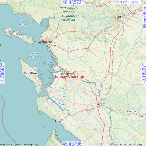
Tonnay-Charente GPS coordinates[2]
45° 56' 56.4" North, 0° 53' 36.6" West
| Map corner | latitude | longitude |
|---|---|---|
| Upper-left | 46.43573°, | -1.59662° |
| Center: | 45.949°, | -0.8935° |
| Lower-right: | 45.45796°, | -0.19037° |
| Map W x H: | 108.7×108.7 km | = 67.5×67.5mi |
| max Lat: | 51.07786° ⇑66.9% North |
| Tonnay-Charente: | 45.949° |
| min Lat: | ⇓33.1% South 41.3874° |
| min Long | Tonnay-Charente | max Long |
| -5.08615° | -0.8935° | 9.52242° |
| W 12.7%⇐ | ⇒87.3% E |
Elevation
Elevation of Tonnay-Charente is 15 m = 49 ft, and this is 178.7 m = 586 ft below average elevation for this country.
| Max E: |
2333 m = 7654 ft | 95.7% |
| Avg. | 193.7 m = 635 ft | |
| Tonnay-Charente | 15 m = 49 ft | |
Min E: |
-1 m = -3 ft | 4.3% |
See also: France elevation on elevation.city.
Geographical zone
Tonnay-Charente is located in North temperate zone (between Tropic of Cancer and the Arctic Circle). Distance of this North polar circle is 2292.1 km =1424.2 mi to North.| Distance of | km | miles | from Tonnay-Charente |
|---|---|---|---|
| North Pole | 4898 | 3043.5 | to North |
| Arctic Circle | 2292.1 | 1424.2 | to North |
| Tropic Cancer | 2503.1 | 1555.4 | to South |
| Equator | 5109 | 3174.6 | to South |


Nearby cities:
15 places around Tonnay-Charente: (largest is in red/bold)
• Beurlay
10.8 km =6.7 mi,  155°
155°
• Bords
9.5 km =5.9 mi,  127°
127°
• Breuil-Magné
6.5 km =4 mi,  307°
307°
• Cabariot
3.8 km =2.4 mi, 131°
• La Vallée
7.7 km =4.8 mi,  147°
147°
• Lussant
5.5 km =3.4 mi,  75°
75°
• Muron
10.7 km =6.6 mi,  27°
27°
• Rochefort
5.7 km =3.5 mi,  262°
262°
• Romegoux
11 km =6.8 mi,  141°
141°
• Saint-Agnant
9.9 km =6.2 mi,  211°
211°
• Saint-Hippolyte
3.4 km =2.1 mi,  177°
177°
• Soubise
9.4 km =5.8 mi,  252°
252°
• Trizay
7.4 km =4.6 mi, 182°
• Vergeroux
7.2 km =4.5 mi,  285°
285°
• Échillais
7 km =4.3 mi,  220°
220°
Sources, notices
• [Note1] Compared only with cities in France existing in our database
• [Src1] Map data: © OpenStreetMap contributors (CC-BY-SA)
• [Src2] Other city data from geonames.org with taken over terms of usage.
• [Src3] Geographical zone / Annual Mean Temperature by Robert A. Rohde @ Wikipedia
