Échillais geodata
Échillais (Nouvelle-Aquitaine) is a populated place; located in France in Europe/Paris (GMT+1) time zone. With population of 3,046 people, there are 3198 cities with bigger population in this country. Compared to other cities in France, 67.6% of cities are located further ↑North; 87.8% of cities are located further →East and 97.8% of cities have higher elevation than Échillais. Note1
Administrative division(s):
- Level 1: Nouvelle-Aquitaine
- Level 2: Charente-Maritime
- Level 3: Arrondissement de Rochefort
- Level 4: Échillais


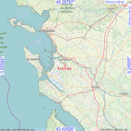
Échillais GPS coordinates[2]
45° 54' 2.592" North, 0° 57' 7.596" West
| Map corner | latitude | longitude |
|---|---|---|
| Upper-left | 46.38787°, | -1.65524° |
| Center: | 45.90072°, | -0.95211° |
| Lower-right: | 45.40926°, | -0.24899° |
| Map W x H: | 108.8×108.8 km | = 67.6×67.6mi |
| max Lat: | 51.07786° ⇑67.6% North |
| Échillais: | 45.90072° |
| min Lat: | ⇓32.4% South 41.3874° |
| min Long | Échillais | max Long |
| -5.08615° | -0.95211° | 9.52242° |
| W 12.2%⇐ | ⇒87.8% E |
Elevation
Elevation of Échillais is 9 m = 30 ft, and this is 184.7 m = 606 ft below average elevation for this country.
| Max E: |
2333 m = 7654 ft | 97.8% |
| Avg. | 193.7 m = 635 ft | |
| Échillais | 9 m = 30 ft | |
Min E: |
-1 m = -3 ft | 2.2% |
See also: France elevation on elevation.city.
Geographical zone
Échillais is located in North temperate zone (between Tropic of Cancer and the Arctic Circle). Distance of this North polar circle is 2297.5 km =1427.6 mi to North.| Distance of | km | miles | from Échillais |
|---|---|---|---|
| North Pole | 4903.4 | 3046.8 | to North |
| Arctic Circle | 2297.5 | 1427.6 | to North |
| Tropic Cancer | 2497.8 | 1552.1 | to South |
| Equator | 5103.7 | 3171.3 | to South |


Nearby cities:
15 places around Échillais: (largest is in red/bold)
• Beurlay
10 km =6.2 mi,  116°
116°
• Breuil-Magné
9.4 km =5.8 mi,  356°
356°
• Cabariot
7.9 km =4.9 mi,  68°
68°
• Champagne
8.4 km =5.2 mi,  156°
156°
• La Vallée
8.7 km =5.4 mi,  97°
97°
• Moëze
6.4 km =4 mi,  273°
273°
• Pont-l’Abbé-d’Arnoult
10 km =6.2 mi,  143°
143°
• Rochefort
4.7 km =2.9 mi,  345°
345°
• Saint-Agnant
3.1 km =1.9 mi,  193°
193°
• Saint-Hippolyte
5.1 km =3.2 mi, 66°
• Saint-Nazaire-sur-Charente
8.7 km =5.4 mi,  297°
297°
• Soubise
5.1 km =3.2 mi, 300°
• Tonnay-Charente
7 km =4.3 mi,  40°
40°
• Trizay
4.7 km =2.9 mi, 115°
• Vergeroux
7.7 km =4.8 mi,  341°
341°
Sources, notices
• [Note1] Compared only with cities in France existing in our database
• [Src1] Map data: © OpenStreetMap contributors (CC-BY-SA)
• [Src2] Other city data from geonames.org with taken over terms of usage.
• [Src3] Geographical zone / Annual Mean Temperature by Robert A. Rohde @ Wikipedia
