Thuir geodata
Thuir (Occitanie) is a populated place; located in France in Europe/Paris (GMT+2) time zone. With population of 7,933 people, there are 1221 cities with bigger population in this country. Compared to other cities in France, 99.2% of cities are located further ↑North; 54.3% of cities are located further ←West and 57.9% of cities have higher elevation than Thuir. Note1
Administrative division(s):
- Level 1: Occitanie
- Level 2: Département des Pyrénées-Orientales
- Level 3: Arrondissement de Céret
- Level 4: Thuir


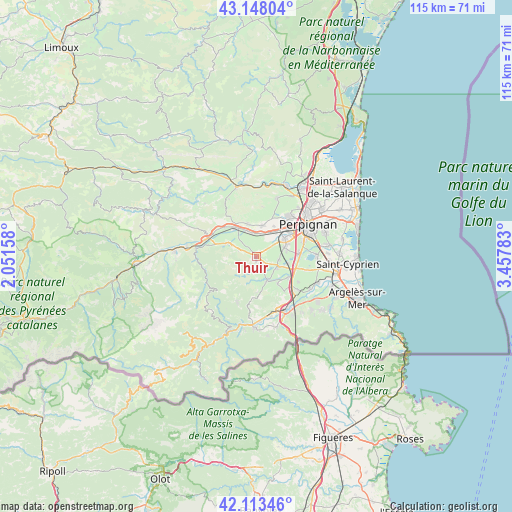
Thuir GPS coordinates[2]
42° 37' 58.44" North, 2° 45' 16.956" East
| Map corner | latitude | longitude |
|---|---|---|
| Upper-left | 43.14804°, | 2.05158° |
| Center: | 42.6329°, | 2.75471° |
| Lower-right: | 42.11346°, | 3.45783° |
| Map W x H: | 115×115 km | = 71.5×71.5mi |
| max Lat: | 51.07786° ⇑99.2% North |
| Thuir: | 42.6329° |
| min Lat: | ⇓0.8% South 41.3874° |
| min Long | Thuir | max Long |
| -5.08615° | 2.75471° | 9.52242° |
| W 54.3%⇐ | ⇒45.7% E |
Elevation
Elevation of Thuir is 108 m = 354 ft, and this is 85.7 m = 281 ft below average elevation for this country.
| Max E: |
2333 m = 7654 ft | 57.9% |
| Avg. | 193.7 m = 635 ft | |
| Thuir | 108 m = 354 ft | |
Min E: |
-1 m = -3 ft | 42.1% |
See also: France elevation on elevation.city.
Geographical zone
Thuir is located in North temperate zone (between Tropic of Cancer and the Arctic Circle). Distance of this Northern Tropic circle is 2134.4 km =1326.3 mi to South.| Distance of | km | miles | from Thuir |
|---|---|---|---|
| North Pole | 5266.7 | 3272.6 | to North |
| Arctic Circle | 2660.8 | 1653.3 | to North |
| Tropic Cancer | 2134.4 | 1326.3 | to South |
| Equator | 4740.3 | 2945.5 | to South |


Nearby cities:
15 places around Thuir: (largest is in red/bold)
• Canohès
7.1 km =4.4 mi,  70°
70°
• Corbère-les-Cabanes
7.1 km =4.4 mi,  292°
292°
• Corneilla-la-Rivière
7.4 km =4.6 mi,  343°
343°
• Fourques
6.1 km =3.8 mi,  161°
161°
• Le Soler
6.2 km =3.9 mi,  30°
30°
• Llupia
1.8 km =1.1 mi,  138°
138°
• Passa
7.6 km =4.7 mi, 142°
• Ponteilla
4.9 km =3 mi,  99°
99°
• Pézilla-la-Rivière
7.1 km =4.4 mi,  10°
10°
• Saint-Féliu-d’Amont
6.5 km =4 mi, 336°
• Saint-Féliu-d’Avall
5.5 km =3.4 mi,  345°
345°
• Terrats
3 km =1.9 mi,  154°
154°
• Toulouges
7.4 km =4.6 mi,  56°
56°
• Trouillas
5 km =3.1 mi,  119°
119°
• Villeneuve-la-Rivière
7.8 km =4.8 mi, 30°
Sources, notices
• [Note1] Compared only with cities in France existing in our database
• [Src1] Map data: © OpenStreetMap contributors (CC-BY-SA)
• [Src2] Other city data from geonames.org with taken over terms of usage.
• [Src3] Geographical zone / Annual Mean Temperature by Robert A. Rohde @ Wikipedia
