Passa geodata
Passa (Occitanie) is a populated place; located in France in Europe/Paris (GMT+2) time zone. With population of 626 people, there are 12883 cities with bigger population in this country. Compared to other cities in France, 99.4% of cities are located further ↑North; 55.1% of cities are located further ←West and 50.1% of cities have lower elevation than Passa. Note1
Administrative division(s):
- Level 1: Occitanie
- Level 2: Département des Pyrénées-Orientales
- Level 3: Arrondissement de Céret
- Level 4: Passa


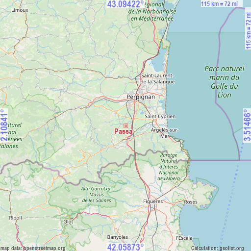
Passa GPS coordinates[2]
42° 34' 43.032" North, 2° 48' 41.508" East
| Map corner | latitude | longitude |
|---|---|---|
| Upper-left | 43.09422°, | 2.10841° |
| Center: | 42.57862°, | 2.81153° |
| Lower-right: | 42.05873°, | 3.51466° |
| Map W x H: | 115.1×115.1 km | = 71.5×71.5mi |
| max Lat: | 51.07786° ⇑99.4% North |
| Passa: | 42.57862° |
| min Lat: | ⇓0.6% South 41.3874° |
| min Long | Passa | max Long |
| -5.08615° | 2.81153° | 9.52242° |
| W 55.1%⇐ | ⇒44.9% E |
Elevation
Elevation of Passa is 132 m = 433 ft, and this is 61.7 m = 202 ft below average elevation for this country.
| Max E: |
2333 m = 7654 ft | 49.9% |
| Avg. | 193.7 m = 635 ft | |
| Passa | 132 m = 433 ft | |
Min E: |
-1 m = -3 ft | 50.1% |
See also: France elevation on elevation.city.
Geographical zone
Passa is located in North temperate zone (between Tropic of Cancer and the Arctic Circle). Distance of this Northern Tropic circle is 2128.4 km =1322.5 mi to South.| Distance of | km | miles | from Passa |
|---|---|---|---|
| North Pole | 5272.8 | 3276.4 | to North |
| Arctic Circle | 2666.9 | 1657.1 | to North |
| Tropic Cancer | 2128.4 | 1322.5 | to South |
| Equator | 4734.3 | 2941.8 | to South |


Nearby cities:
15 places around Passa: (largest is in red/bold)
• Bages
7.4 km =4.6 mi,  65°
65°
• Banyuls-dels-Aspres
4.7 km =2.9 mi,  107°
107°
• Brouilla
7.6 km =4.7 mi,  100°
100°
• Fourques
2.7 km =1.7 mi,  275°
275°
• Llupia
5.8 km =3.6 mi,  323°
323°
• Pollestres
8.6 km =5.3 mi,  34°
34°
• Ponteilla
5.3 km =3.3 mi,  1°
1°
• Saint-Jean-Lasseille
4.6 km =2.9 mi,  85°
85°
• Sant Joan de Pladecorts
7.7 km =4.8 mi,  192°
192°
• Terrats
4.7 km =2.9 mi,  314°
314°
• Thuir
7.6 km =4.7 mi, 322°
• Tresserre
2.2 km =1.4 mi,  137°
137°
• Trouillas
3.6 km =2.2 mi,  355°
355°
• Villemolaque
2.5 km =1.6 mi,  64°
64°
• el Voló
6.3 km =3.9 mi,  163°
163°
Sources, notices
• [Note1] Compared only with cities in France existing in our database
• [Src1] Map data: © OpenStreetMap contributors (CC-BY-SA)
• [Src2] Other city data from geonames.org with taken over terms of usage.
• [Src3] Geographical zone / Annual Mean Temperature by Robert A. Rohde @ Wikipedia
