Llupia geodata
Llupia (Occitanie) is a populated place; located in France in Europe/Paris (GMT+2) time zone. With population of 1,893 people, there are 5047 cities with bigger population in this country. Compared to other cities in France, 99.2% of cities are located further ↑North; 54.5% of cities are located further ←West and 57.9% of cities have higher elevation than Llupia. Note1
Administrative division(s):
- Level 1: Occitanie
- Level 2: Département des Pyrénées-Orientales
- Level 3: Arrondissement de Perpignan
- Level 4: Llupia


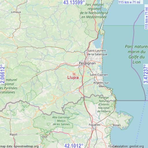
Llupia GPS coordinates[2]
42° 37' 14.664" North, 2° 46' 9.264" East
| Map corner | latitude | longitude |
|---|---|---|
| Upper-left | 43.13599°, | 2.06612° |
| Center: | 42.62074°, | 2.76924° |
| Lower-right: | 42.1012°, | 3.47237° |
| Map W x H: | 115.1×115.1 km | = 71.5×71.5mi |
| max Lat: | 51.07786° ⇑99.2% North |
| Llupia: | 42.62074° |
| min Lat: | ⇓0.8% South 41.3874° |
| min Long | Llupia | max Long |
| -5.08615° | 2.76924° | 9.52242° |
| W 54.5%⇐ | ⇒45.5% E |
Elevation
Elevation of Llupia is 108 m = 354 ft, and this is 85.7 m = 281 ft below average elevation for this country.
| Max E: |
2333 m = 7654 ft | 57.9% |
| Avg. | 193.7 m = 635 ft | |
| Llupia | 108 m = 354 ft | |
Min E: |
-1 m = -3 ft | 42.1% |
See also: France elevation on elevation.city.
Geographical zone
Llupia is located in North temperate zone (between Tropic of Cancer and the Arctic Circle). Distance of this Northern Tropic circle is 2133.1 km =1325.4 mi to South.| Distance of | km | miles | from Llupia |
|---|---|---|---|
| North Pole | 5268.1 | 3273.4 | to North |
| Arctic Circle | 2662.2 | 1654.2 | to North |
| Tropic Cancer | 2133.1 | 1325.4 | to South |
| Equator | 4739 | 2944.7 | to South |


Nearby cities:
15 places around Llupia: (largest is in red/bold)
• Canohès
6.7 km =4.2 mi,  55°
55°
• Fourques
4.5 km =2.8 mi,  170°
170°
• Le Soler
7 km =4.3 mi,  16°
16°
• Passa
5.8 km =3.6 mi,  143°
143°
• Ponteilla
3.7 km =2.3 mi,  80°
80°
• Pézilla-la-Rivière
8.3 km =5.2 mi,  1°
1°
• Saint-Féliu-d’Amont
8.3 km =5.2 mi,  332°
332°
• Saint-Féliu-d’Avall
7.2 km =4.5 mi,  339°
339°
• Terrats
1.4 km =0.9 mi,  176°
176°
• Thuir
1.8 km =1.1 mi,  318°
318°
• Toulouges
7.4 km =4.6 mi,  42°
42°
• Tresserre
8 km =5 mi, 141°
• Trouillas
3.4 km =2.1 mi,  108°
108°
• Villemolaque
6.8 km =4.2 mi,  122°
122°
• Villeneuve-la-Rivière
8.6 km =5.3 mi, 18°
Sources, notices
• [Note1] Compared only with cities in France existing in our database
• [Src1] Map data: © OpenStreetMap contributors (CC-BY-SA)
• [Src2] Other city data from geonames.org with taken over terms of usage.
• [Src3] Geographical zone / Annual Mean Temperature by Robert A. Rohde @ Wikipedia
