Thorey-en-Plaine geodata
Thorey-en-Plaine (Bourgogne-Franche-Comté) is a populated place; located in France in Europe/Paris (GMT+2) time zone. With population of 856 people, there are 10023 cities with bigger population in this country. Compared to other cities in France, 52.8% of cities are located further ↑North; 79.1% of cities are located further ←West and 66.4% of cities have lower elevation than Thorey-en-Plaine. Note1
Administrative division(s):
- Level 1: Bourgogne-Franche-Comté
- Level 2: Département de la Côte-d'Or
- Level 3: Arrondissement de Dijon
- Level 4: Thorey-en-Plaine


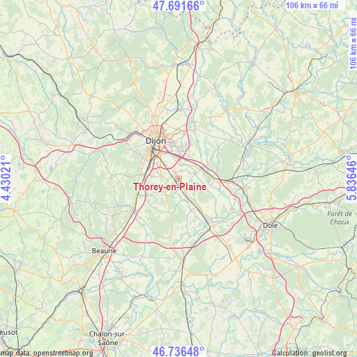
Thorey-en-Plaine GPS coordinates[2]
47° 12' 58.392" North, 5° 7' 59.988" East
| Map corner | latitude | longitude |
|---|---|---|
| Upper-left | 47.69166°, | 4.43021° |
| Center: | 47.21622°, | 5.13333° |
| Lower-right: | 46.73648°, | 5.83646° |
| Map W x H: | 106.2×106.2 km | = 66×66mi |
| max Lat: | 51.07786° ⇑52.8% North |
| Thorey-en-Plaine: | 47.21622° |
| min Lat: | ⇓47.2% South 41.3874° |
| min Long | Thorey-en-Plain | max Long |
| -5.08615° | 5.13333° | 9.52242° |
| W 79.1%⇐ | ⇒20.9% E |
Elevation
Elevation of Thorey-en-Plaine is 201 m = 659 ft, and this is 7.3 m = 24 ft above average elevation for this country.
| Max E: |
2333 m = 7654 ft | 33.6% |
| Thorey-en-Plaine | 201 m 659 ft | |
| Avg. | 193.7 m = 635 ft | |
Min E: |
-1 m = -3 ft | 66.4% |
See also: France elevation on elevation.city.
Geographical zone
Thorey-en-Plaine is located in North temperate zone (between Tropic of Cancer and the Arctic Circle). Distance of this North polar circle is 2151.2 km =1336.7 mi to North.| Distance of | km | miles | from Thorey-en-Plaine |
|---|---|---|---|
| North Pole | 4757.1 | 2955.9 | to North |
| Arctic Circle | 2151.2 | 1336.7 | to North |
| Tropic Cancer | 2644 | 1642.9 | to South |
| Equator | 5250 | 3262.2 | to South |


Nearby cities:
15 places around Thorey-en-Plaine: (largest is in red/bold)
• Aiserey
5.4 km =3.4 mi,  155°
155°
• Bretenière
3.1 km =1.9 mi,  332°
332°
• Corcelles-lès-Cîteaux
6.3 km =3.9 mi,  218°
218°
• Crimolois
6.4 km =4 mi,  351°
351°
• Fauverney
4.4 km =2.7 mi,  11°
11°
• Fénay
5.7 km =3.5 mi,  287°
287°
• Izeure
5.1 km =3.2 mi,  176°
176°
• Longecourt-en-Plaine
2.4 km =1.5 mi,  149°
149°
• Noiron-sous-Gevrey
4.8 km =3 mi,  239°
239°
• Ouges
6.8 km =4.2 mi,  318°
318°
• Rouvres-en-Plaine
2.6 km =1.6 mi, 13°
• Saulon-la-Chapelle
3.4 km =2.1 mi,  266°
266°
• Saulon-la-Rue
5.3 km =3.3 mi,  276°
276°
• Tart-le-Haut
5.6 km =3.5 mi,  104°
104°
• Varanges
4.9 km =3 mi,  70°
70°
Sources, notices
• [Note1] Compared only with cities in France existing in our database
• [Src1] Map data: © OpenStreetMap contributors (CC-BY-SA)
• [Src2] Other city data from geonames.org with taken over terms of usage.
• [Src3] Geographical zone / Annual Mean Temperature by Robert A. Rohde @ Wikipedia
