Tart-le-Haut geodata
Tart-le-Haut (Bourgogne-Franche-Comté) is a populated place; located in France in Europe/Paris (GMT+2) time zone. With population of 831 people, there are 10280 cities with bigger population in this country. Compared to other cities in France, 52.9% of cities are located further ↑North; 79.9% of cities are located further ←West and 72.5% of cities have lower elevation than Tart-le-Haut. Note1
Administrative division(s):
- Level 1: Bourgogne-Franche-Comté
- Level 2: Département de la Côte-d'Or
- Level 3: Arrondissement de Dijon
- Level 4: Tart


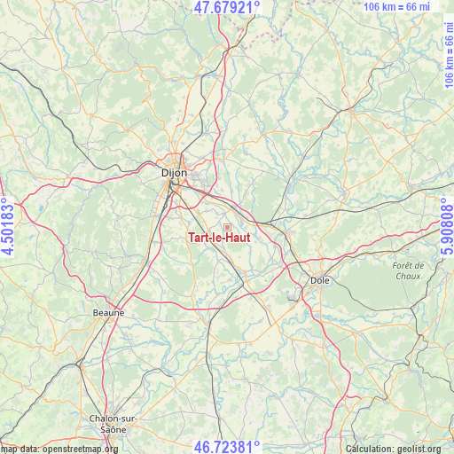
Tart-le-Haut GPS coordinates[2]
47° 12' 13.176" North, 5° 12' 17.82" East
| Map corner | latitude | longitude |
|---|---|---|
| Upper-left | 47.67921°, | 4.50183° |
| Center: | 47.20366°, | 5.20495° |
| Lower-right: | 46.72381°, | 5.90808° |
| Map W x H: | 106.2×106.2 km | = 66×66mi |
| max Lat: | 51.07786° ⇑52.9% North |
| Tart-le-Haut: | 47.20366° |
| min Lat: | ⇓47.1% South 41.3874° |
| min Long | Tart-le-Haut | max Long |
| -5.08615° | 5.20495° | 9.52242° |
| W 79.9%⇐ | ⇒20.1% E |
Elevation
Elevation of Tart-le-Haut is 233 m = 764 ft, and this is 39.3 m = 129 ft above average elevation for this country.
| Max E: |
2333 m = 7654 ft | 27.5% |
| Tart-le-Haut | 233 m 764 ft | |
| Avg. | 193.7 m = 635 ft | |
Min E: |
-1 m = -3 ft | 72.5% |
See also: France elevation on elevation.city.
Geographical zone
Tart-le-Haut is located in North temperate zone (between Tropic of Cancer and the Arctic Circle). Distance of this North polar circle is 2152.6 km =1337.6 mi to North.| Distance of | km | miles | from Tart-le-Haut |
|---|---|---|---|
| North Pole | 4758.5 | 2956.8 | to North |
| Arctic Circle | 2152.6 | 1337.6 | to North |
| Tropic Cancer | 2642.6 | 1642 | to South |
| Equator | 5248.6 | 3261.3 | to South |


Nearby cities:
15 places around Tart-le-Haut: (largest is in red/bold)
• Aiserey
4.7 km =2.9 mi,  222°
222°
• Brazey-en-Plaine
7.4 km =4.6 mi,  173°
173°
• Bretenière
8 km =5 mi,  301°
301°
• Champdôtre
7.9 km =4.9 mi,  108°
108°
• Collonges-lès-Premières
5.2 km =3.2 mi,  63°
63°
• Fauverney
7.3 km =4.5 mi,  321°
321°
• Genlis
4.5 km =2.8 mi,  18°
18°
• Izeure
6.3 km =3.9 mi,  233°
233°
• Longeault
4.1 km =2.5 mi, 62°
• Longecourt-en-Plaine
4.2 km =2.6 mi,  261°
261°
• Pluvault
3.8 km =2.4 mi,  75°
75°
• Rouvres-en-Plaine
6.2 km =3.9 mi,  309°
309°
• Thorey-en-Plaine
5.6 km =3.5 mi,  284°
284°
• Trouhans
8.1 km =5 mi,  139°
139°
• Varanges
3.1 km =1.9 mi,  346°
346°
Sources, notices
• [Note1] Compared only with cities in France existing in our database
• [Src1] Map data: © OpenStreetMap contributors (CC-BY-SA)
• [Src2] Other city data from geonames.org with taken over terms of usage.
• [Src3] Geographical zone / Annual Mean Temperature by Robert A. Rohde @ Wikipedia
