Theys geodata
Theys (Auvergne-Rhône-Alpes) is a populated place; located in France in Europe/Paris (GMT+2) time zone. With population of 1,730 people, there are 5450 cities with bigger population in this country. Compared to other cities in France, 76.3% of cities are located further ↑North; 87% of cities are located further ←West and 96.7% of cities have lower elevation than Theys. Note1
Administrative division(s):
- Level 1: Auvergne-Rhône-Alpes
- Level 2: Département de l'Isère
- Level 3: Arrondissement de Grenoble
- Level 4: Theys


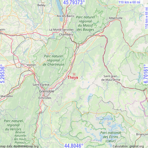
Theys GPS coordinates[2]
45° 18' 4.752" North, 5° 59' 54.528" East
| Map corner | latitude | longitude |
|---|---|---|
| Upper-left | 45.79373°, | 5.29536° |
| Center: | 45.30132°, | 5.99848° |
| Lower-right: | 44.8046°, | 6.70161° |
| Map W x H: | 110×110 km | = 68.4×68.4mi |
| max Lat: | 51.07786° ⇑76.3% North |
| Theys: | 45.30132° |
| min Lat: | ⇓23.7% South 41.3874° |
| min Long | Theys | max Long |
| -5.08615° | 5.99848° | 9.52242° |
| W 87%⇐ | ⇒13% E |
Elevation
Elevation of Theys is 703 m = 2306 ft, and this is 509.3 m = 1671 ft above average elevation for this country.
| Max E: |
2333 m = 7654 ft | 3.3% |
| Theys | 703 m 2306 ft | |
| Avg. | 193.7 m = 635 ft | |
Min E: |
-1 m = -3 ft | 96.7% |
See also: France elevation on elevation.city.
Geographical zone
Theys is located in North temperate zone (between Tropic of Cancer and the Arctic Circle). Distance of this North polar circle is 2364.1 km =1469 mi to North.| Distance of | km | miles | from Theys |
|---|---|---|---|
| North Pole | 4970 | 3088.2 | to North |
| Arctic Circle | 2364.1 | 1469 | to North |
| Tropic Cancer | 2431.1 | 1510.6 | to South |
| Equator | 5037 | 3129.8 | to South |


Nearby cities:
15 places around Theys: (largest is in red/bold)
• Crolles
9.8 km =6.1 mi,  254°
254°
• Froges
6.8 km =4.2 mi,  243°
243°
• Goncelin
5 km =3.1 mi,  342°
342°
• La Terrasse
5.9 km =3.7 mi,  291°
291°
• Laval
7.4 km =4.6 mi,  223°
223°
• Le Champ-près-Froges
5.1 km =3.2 mi, 243°
• Le Cheylas
7.7 km =4.8 mi,  356°
356°
• Le Touvet
7.3 km =4.5 mi,  330°
330°
• Les Adrets
4.2 km =2.6 mi, 217°
• Lumbin
6.6 km =4.1 mi,  277°
277°
• Saint-Bernard
8.1 km =5 mi, 292°
• Saint-Hilaire
9 km =5.6 mi,  269°
269°
• Saint-Vincent-de-Mercuze
8.6 km =5.3 mi, 336°
• Sainte-Agnès
9.4 km =5.8 mi, 219°
• Tencin
3.4 km =2.1 mi, 288°
Sources, notices
• [Note1] Compared only with cities in France existing in our database
• [Src1] Map data: © OpenStreetMap contributors (CC-BY-SA)
• [Src2] Other city data from geonames.org with taken over terms of usage.
• [Src3] Geographical zone / Annual Mean Temperature by Robert A. Rohde @ Wikipedia
