Saint-Bernard geodata
Saint-Bernard (Auvergne-Rhône-Alpes) is a populated place; located in France in Europe/Paris (GMT+2) time zone. With population of 512 people, there are 14990 cities with bigger population in this country. Compared to other cities in France, 76% of cities are located further ↑North; 86% of cities are located further ←West and 98.8% of cities have lower elevation than Saint-Bernard. Note1
Administrative division(s):
- Level 1: Auvergne-Rhône-Alpes
- Level 2: Département de l'Isère
- Level 3: Arrondissement de Grenoble
- Level 4: Plateau-des-Petites-Roches


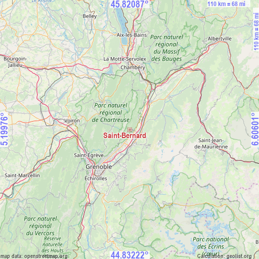
Saint-Bernard GPS coordinates[2]
45° 19' 43.32" North, 5° 54' 10.368" East
| Map corner | latitude | longitude |
|---|---|---|
| Upper-left | 45.82087°, | 5.19976° |
| Center: | 45.3287°, | 5.90288° |
| Lower-right: | 44.83222°, | 6.60601° |
| Map W x H: | 109.9×109.9 km | = 68.3×68.3mi |
| max Lat: | 51.07786° ⇑76% North |
| Saint-Bernard: | 45.3287° |
| min Lat: | ⇓24% South 41.3874° |
| min Long | Saint-Bernard | max Long |
| -5.08615° | 5.90288° | 9.52242° |
| W 86%⇐ | ⇒14% E |
Elevation
Elevation of Saint-Bernard is 920 m = 3018 ft, and this is 726.3 m = 2383 ft above average elevation for this country.
| Max E: |
2333 m = 7654 ft | 1.2% |
| Saint-Bernard | 920 m 3018 ft | |
| Avg. | 193.7 m = 635 ft | |
Min E: |
-1 m = -3 ft | 98.8% |
See also: France elevation on elevation.city.
Geographical zone
Saint-Bernard is located in North temperate zone (between Tropic of Cancer and the Arctic Circle). Distance of this North polar circle is 2361.1 km =1467.1 mi to North.| Distance of | km | miles | from Saint-Bernard |
|---|---|---|---|
| North Pole | 4967 | 3086.3 | to North |
| Arctic Circle | 2361.1 | 1467.1 | to North |
| Tropic Cancer | 2434.2 | 1512.5 | to South |
| Equator | 5040.1 | 3131.8 | to South |


Nearby cities:
15 places around Saint-Bernard: (largest is in red/bold)
• Bernin
7.4 km =4.6 mi,  203°
203°
• Crolles
6 km =3.7 mi, 198°
• Froges
6.3 km =3.9 mi,  166°
166°
• Goncelin
6.2 km =3.9 mi,  73°
73°
• La Terrasse
2.1 km =1.3 mi,  115°
115°
• Le Champ-près-Froges
6.1 km =3.8 mi,  151°
151°
• Le Cheylas
8.4 km =5.2 mi,  56°
56°
• Le Touvet
5.2 km =3.2 mi,  49°
49°
• Les Adrets
8.1 km =5 mi,  142°
142°
• Lumbin
2.3 km =1.4 mi,  155°
155°
• Saint-Hilaire
3.5 km =2.2 mi,  205°
205°
• Saint-Pierre-de-Chartreuse
7 km =4.3 mi,  282°
282°
• Saint-Vincent-de-Mercuze
6.3 km =3.9 mi,  39°
39°
• Tencin
4.7 km =2.9 mi,  114°
114°
• Theys
8.1 km =5 mi, 112°
Sources, notices
• [Note1] Compared only with cities in France existing in our database
• [Src1] Map data: © OpenStreetMap contributors (CC-BY-SA)
• [Src2] Other city data from geonames.org with taken over terms of usage.
• [Src3] Geographical zone / Annual Mean Temperature by Robert A. Rohde @ Wikipedia
