Tencin geodata
Tencin (Auvergne-Rhône-Alpes) is a populated place; located in France in Europe/Paris (GMT+2) time zone. With population of 1,165 people, there are 7732 cities with bigger population in this country. Compared to other cities in France, 76.2% of cities are located further ↑North; 86.6% of cities are located further ←West and 74.4% of cities have lower elevation than Tencin. Note1
Administrative division(s):
- Level 1: Auvergne-Rhône-Alpes
- Level 2: Département de l'Isère
- Level 3: Arrondissement de Grenoble
- Level 4: Tencin


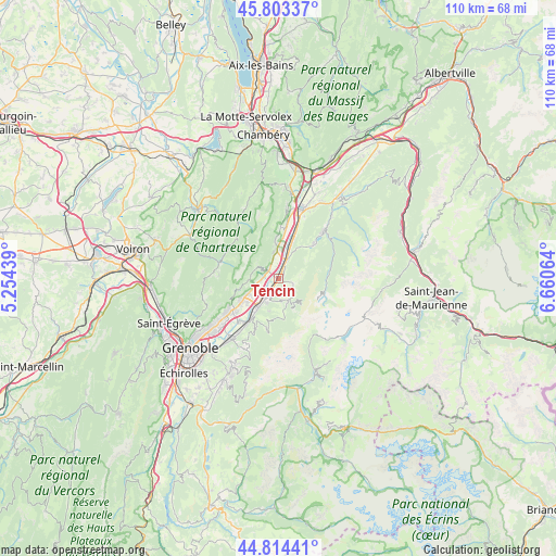
Tencin GPS coordinates[2]
45° 18' 39.78" North, 5° 57' 27.072" East
| Map corner | latitude | longitude |
|---|---|---|
| Upper-left | 45.80337°, | 5.25439° |
| Center: | 45.31105°, | 5.95752° |
| Lower-right: | 44.81441°, | 6.66064° |
| Map W x H: | 110×110 km | = 68.4×68.4mi |
| max Lat: | 51.07786° ⇑76.2% North |
| Tencin: | 45.31105° |
| min Lat: | ⇓23.8% South 41.3874° |
| min Long | Tencin | max Long |
| -5.08615° | 5.95752° | 9.52242° |
| W 86.6%⇐ | ⇒13.4% E |
Elevation
Elevation of Tencin is 245 m = 804 ft, and this is 51.3 m = 168 ft above average elevation for this country.
| Max E: |
2333 m = 7654 ft | 25.6% |
| Tencin | 245 m 804 ft | |
| Avg. | 193.7 m = 635 ft | |
Min E: |
-1 m = -3 ft | 74.4% |
See also: France elevation on elevation.city.
Geographical zone
Tencin is located in North temperate zone (between Tropic of Cancer and the Arctic Circle). Distance of this North polar circle is 2363.1 km =1468.4 mi to North.| Distance of | km | miles | from Tencin |
|---|---|---|---|
| North Pole | 4968.9 | 3087.5 | to North |
| Arctic Circle | 2363.1 | 1468.4 | to North |
| Tropic Cancer | 2432.2 | 1511.3 | to South |
| Equator | 5038.1 | 3130.5 | to South |


Nearby cities:
15 places around Tencin: (largest is in red/bold)
• Crolles
7.2 km =4.5 mi,  238°
238°
• Froges
5 km =3.1 mi,  214°
214°
• Goncelin
4.1 km =2.5 mi,  24°
24°
• La Terrasse
2.6 km =1.6 mi,  294°
294°
• Laval
6.7 km =4.2 mi,  196°
196°
• Le Champ-près-Froges
3.7 km =2.3 mi, 202°
• Le Cheylas
7.2 km =4.5 mi, 22°
• Le Touvet
5.4 km =3.4 mi,  356°
356°
• Les Adrets
4.5 km =2.8 mi,  171°
171°
• Lumbin
3.3 km =2.1 mi,  267°
267°
• Saint-Bernard
4.7 km =2.9 mi, 294°
• Saint-Hilaire
5.9 km =3.7 mi,  258°
258°
• Saint-Vincent-de-Mercuze
6.8 km =4.2 mi, 357°
• Sainte-Agnès
8.7 km =5.4 mi, 198°
• Theys
3.4 km =2.1 mi,  108°
108°
Sources, notices
• [Note1] Compared only with cities in France existing in our database
• [Src1] Map data: © OpenStreetMap contributors (CC-BY-SA)
• [Src2] Other city data from geonames.org with taken over terms of usage.
• [Src3] Geographical zone / Annual Mean Temperature by Robert A. Rohde @ Wikipedia
