Teting-sur-Nied geodata
Teting-sur-Nied (Grand Est) is a populated place; located in France in Europe/Paris (GMT+2) time zone. With population of 1,220 people, there are 7433 cities with bigger population in this country. Compared to other cities in France, 81.1% of cities are located further ↓South; 92.8% of cities are located further ←West and 76.4% of cities have lower elevation than Teting-sur-Nied. Note1
Administrative division(s):
- Level 1: Grand Est
- Level 2: Moselle
- Level 3: Arrondissement de Forbach-Boulay-Moselle
- Level 4: Teting-sur-Nied


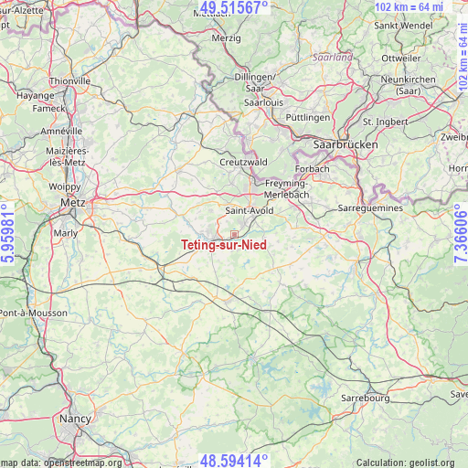
Teting-sur-Nied GPS coordinates[2]
49° 3' 25.344" North, 6° 39' 46.584" East
| Map corner | latitude | longitude |
|---|---|---|
| Upper-left | 49.51567°, | 5.95981° |
| Center: | 49.05704°, | 6.66294° |
| Lower-right: | 48.59414°, | 7.36606° |
| Map W x H: | 102.5×102.5 km | = 63.7×63.7mi |
| max Lat: | 51.07786° ⇑18.9% North |
| Teting-sur-Nied: | 49.05704° |
| min Lat: | ⇓81.1% South 41.3874° |
| min Long | Teting-sur-Nied | max Long |
| -5.08615° | 6.66294° | 9.52242° |
| W 92.8%⇐ | ⇒7.2% E |
Elevation
Elevation of Teting-sur-Nied is 259 m = 850 ft, and this is 65.3 m = 214 ft above average elevation for this country.
| Max E: |
2333 m = 7654 ft | 23.6% |
| Teting-sur-Nied | 259 m 850 ft | |
| Avg. | 193.7 m = 635 ft | |
Min E: |
-1 m = -3 ft | 76.4% |
See also: France elevation on elevation.city.
Geographical zone
Teting-sur-Nied is located in North temperate zone (between Tropic of Cancer and the Arctic Circle). Distance of this North polar circle is 1946.5 km =1209.5 mi to North.| Distance of | km | miles | from Teting-sur-Nied |
|---|---|---|---|
| North Pole | 4552.4 | 2828.7 | to North |
| Arctic Circle | 1946.5 | 1209.5 | to North |
| Tropic Cancer | 2848.7 | 1770.1 | to South |
| Equator | 5454.6 | 3389.3 | to South |


Nearby cities:
15 places around Teting-sur-Nied: (largest is in red/bold)
• Altviller
5.4 km =3.4 mi,  69°
69°
• Bambiderstroff
7.3 km =4.5 mi,  314°
314°
• Créhange
5.9 km =3.7 mi,  272°
272°
• Faulquemont
4.9 km =3 mi,  259°
259°
• Flétrange
7.3 km =4.5 mi,  275°
275°
• Folschviller
2.7 km =1.7 mi,  33°
33°
• Guessling-Hémering
3.6 km =2.2 mi,  185°
185°
• Lachambre
6.6 km =4.1 mi, 65°
• Laning
8.5 km =5.3 mi,  106°
106°
• Lixing-lès-Saint-Avold
6.9 km =4.3 mi, 109°
• Longeville-lès-Saint-Avold
6.8 km =4.2 mi,  347°
347°
• Pontpierre
2.2 km =1.4 mi,  228°
228°
• Saint-Avold
6.1 km =3.8 mi, 29°
• Vahl-Ebersing
6.6 km =4.1 mi,  97°
97°
• Valmont
4 km =2.5 mi,  39°
39°
Sources, notices
• [Note1] Compared only with cities in France existing in our database
• [Src1] Map data: © OpenStreetMap contributors (CC-BY-SA)
• [Src2] Other city data from geonames.org with taken over terms of usage.
• [Src3] Geographical zone / Annual Mean Temperature by Robert A. Rohde @ Wikipedia
