Téterchen geodata
Téterchen (Grand Est) is a populated place; located in France in Europe/Paris (GMT+2) time zone. With population of 624 people, there are 12917 cities with bigger population in this country. Compared to other cities in France, 84.8% of cities are located further ↓South; 92.1% of cities are located further ←West and 78.5% of cities have lower elevation than Téterchen. Note1
Administrative division(s):
- Level 1: Grand Est
- Level 2: Moselle
- Level 3: Arrondissement de Forbach-Boulay-Moselle
- Level 4: Téterchen


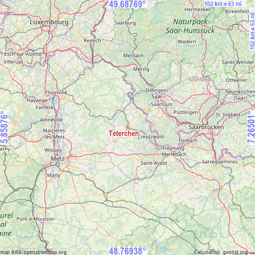
Téterchen GPS coordinates[2]
49° 13' 50.412" North, 6° 33' 42.768" East
| Map corner | latitude | longitude |
|---|---|---|
| Upper-left | 49.68769°, | 5.85876° |
| Center: | 49.23067°, | 6.56188° |
| Lower-right: | 48.76938°, | 7.26501° |
| Map W x H: | 102.1×102.1 km | = 63.4×63.4mi |
| max Lat: | 51.07786° ⇑15.2% North |
| Téterchen: | 49.23067° |
| min Lat: | ⇓84.8% South 41.3874° |
| min Long | Téterchen | max Long |
| -5.08615° | 6.56188° | 9.52242° |
| W 92.1%⇐ | ⇒7.9% E |
Elevation
Elevation of Téterchen is 276 m = 906 ft, and this is 82.3 m = 270 ft above average elevation for this country.
| Max E: |
2333 m = 7654 ft | 21.5% |
| Téterchen | 276 m 906 ft | |
| Avg. | 193.7 m = 635 ft | |
Min E: |
-1 m = -3 ft | 78.5% |
See also: France elevation on elevation.city.
Geographical zone
Téterchen is located in North temperate zone (between Tropic of Cancer and the Arctic Circle). Distance of this North polar circle is 1927.2 km =1197.5 mi to North.| Distance of | km | miles | from Téterchen |
|---|---|---|---|
| North Pole | 4533.1 | 2816.7 | to North |
| Arctic Circle | 1927.2 | 1197.5 | to North |
| Tropic Cancer | 2868 | 1782.1 | to South |
| Equator | 5473.9 | 3401.3 | to South |


Nearby cities:
15 places around Téterchen: (largest is in red/bold)
• Boulay-Moselle
6.9 km =4.3 mi,  220°
220°
• Bouzonville
7.1 km =4.4 mi,  343°
343°
• Coume
3.7 km =2.3 mi,  167°
167°
• Creutzwald
10.2 km =6.3 mi,  106°
106°
• Dalem
3.8 km =2.4 mi,  72°
72°
• Diesen
10.3 km =6.4 mi,  124°
124°
• Falck
5.2 km =3.2 mi,  94°
94°
• Freistroff
7.7 km =4.8 mi,  317°
317°
• Guerting
6.5 km =4 mi,  136°
136°
• Ham-sous-Varsberg
8.4 km =5.2 mi,  132°
132°
• Hargarten-aux-Mines
3.9 km =2.4 mi,  100°
100°
• Heining-lès-Bouzonville
9.1 km =5.7 mi,  13°
13°
• Merten
7.7 km =4.8 mi, 74°
• Varsberg
8.1 km =5 mi, 142°
• Vaudreching
6.5 km =4 mi, 335°
Sources, notices
• [Note1] Compared only with cities in France existing in our database
• [Src1] Map data: © OpenStreetMap contributors (CC-BY-SA)
• [Src2] Other city data from geonames.org with taken over terms of usage.
• [Src3] Geographical zone / Annual Mean Temperature by Robert A. Rohde @ Wikipedia
