Taverny geodata
Taverny (Île-de-France) is a populated place; located in France in Europe/Paris (GMT+2) time zone. With population of 27,271 people, there are 311 cities with bigger population in this country. Compared to other cities in France, 80.3% of cities are located further ↓South; 54.2% of cities are located further →East and 68.3% of cities have higher elevation than Taverny. Note1
Administrative division(s):
- Level 1: Île-de-France
- Level 2: Département du Val-d’Oise
- Level 3: Arrondissement d'Argenteuil
- Level 4: Taverny


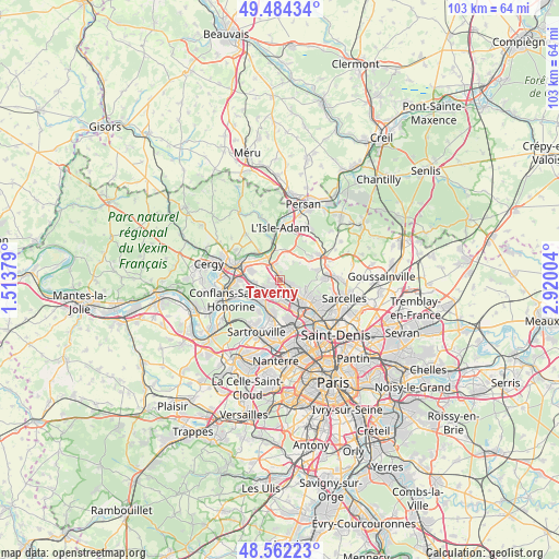
Taverny GPS coordinates[2]
49° 1' 31.512" North, 2° 13' 0.876" East
| Map corner | latitude | longitude |
|---|---|---|
| Upper-left | 49.48434°, | 1.51379° |
| Center: | 49.02542°, | 2.21691° |
| Lower-right: | 48.56223°, | 2.92004° |
| Map W x H: | 102.5×102.5 km | = 63.7×63.7mi |
| max Lat: | 51.07786° ⇑19.7% North |
| Taverny: | 49.02542° |
| min Lat: | ⇓80.3% South 41.3874° |
| min Long | Taverny | max Long |
| -5.08615° | 2.21691° | 9.52242° |
| W 45.8%⇐ | ⇒54.2% E |
Elevation
Elevation of Taverny is 82 m = 269 ft, and this is 111.7 m = 366 ft below average elevation for this country.
| Max E: |
2333 m = 7654 ft | 68.3% |
| Avg. | 193.7 m = 635 ft | |
| Taverny | 82 m = 269 ft | |
Min E: |
-1 m = -3 ft | 31.7% |
See also: France elevation on elevation.city.
Geographical zone
Taverny is located in North temperate zone (between Tropic of Cancer and the Arctic Circle). Distance of this North polar circle is 1950.1 km =1211.7 mi to North.| Distance of | km | miles | from Taverny |
|---|---|---|---|
| North Pole | 4555.9 | 2830.9 | to North |
| Arctic Circle | 1950.1 | 1211.7 | to North |
| Tropic Cancer | 2845.2 | 1767.9 | to South |
| Equator | 5451.1 | 3387.2 | to South |


Nearby cities:
15 places around Taverny: (largest is in red/bold)
• Beauchamp
1.6 km =1 mi,  231°
231°
• Bessancourt
1.5 km =0.9 mi,  337°
337°
• Eaubonne
5.7 km =3.5 mi,  123°
123°
• Ermont
4.9 km =3 mi,  142°
142°
• Franconville
4.8 km =3 mi,  165°
165°
• Frépillon
3.1 km =1.9 mi, 344°
• Herblay
5.2 km =3.2 mi,  220°
220°
• Le Plessis-Bouchard
3.1 km =1.9 mi,  157°
157°
• Montigny-lès-Cormeilles
5 km =3.1 mi,  194°
194°
• Montlignon
5.5 km =3.4 mi,  112°
112°
• Méry-sur-Oise
4.2 km =2.6 mi,  333°
333°
• Pierrelaye
4.6 km =2.9 mi,  263°
263°
• Saint-Leu-la-Forêt
2.6 km =1.6 mi, 111°
• Saint-Prix
3.8 km =2.4 mi, 105°
• Villiers-Adam
4.5 km =2.8 mi,  16°
16°
Sources, notices
• [Note1] Compared only with cities in France existing in our database
• [Src1] Map data: © OpenStreetMap contributors (CC-BY-SA)
• [Src2] Other city data from geonames.org with taken over terms of usage.
• [Src3] Geographical zone / Annual Mean Temperature by Robert A. Rohde @ Wikipedia
