Frépillon geodata
Frépillon (Île-de-France) is a populated place; located in France in Europe/Paris (GMT+2) time zone. With population of 2,399 people, there are 4036 cities with bigger population in this country. Compared to other cities in France, 81% of cities are located further ↓South; 54.4% of cities are located further →East and 60.8% of cities have higher elevation than Frépillon. Note1
Administrative division(s):
- Level 1: Île-de-France
- Level 2: Département du Val-d’Oise
- Level 3: Arrondissement d'Argenteuil
- Level 4: Frépillon


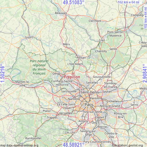
Frépillon GPS coordinates[2]
49° 3' 7.776" North, 2° 12' 19.008" East
| Map corner | latitude | longitude |
|---|---|---|
| Upper-left | 49.51083°, | 1.50216° |
| Center: | 49.05216°, | 2.20528° |
| Lower-right: | 48.58921°, | 2.90841° |
| Map W x H: | 102.5×102.5 km | = 63.7×63.7mi |
| max Lat: | 51.07786° ⇑19% North |
| Frépillon: | 49.05216° |
| min Lat: | ⇓81% South 41.3874° |
| min Long | Frépillon | max Long |
| -5.08615° | 2.20528° | 9.52242° |
| W 45.6%⇐ | ⇒54.4% E |
Elevation
Elevation of Frépillon is 100 m = 328 ft, and this is 93.7 m = 307 ft below average elevation for this country.
| Max E: |
2333 m = 7654 ft | 60.8% |
| Avg. | 193.7 m = 635 ft | |
| Frépillon | 100 m = 328 ft | |
Min E: |
-1 m = -3 ft | 39.2% |
See also: France elevation on elevation.city.
Geographical zone
Frépillon is located in North temperate zone (between Tropic of Cancer and the Arctic Circle). Distance of this North polar circle is 1947.1 km =1209.9 mi to North.| Distance of | km | miles | from Frépillon |
|---|---|---|---|
| North Pole | 4553 | 2829.1 | to North |
| Arctic Circle | 1947.1 | 1209.9 | to North |
| Tropic Cancer | 2848.2 | 1769.8 | to South |
| Equator | 5454.1 | 3389 | to South |


Nearby cities:
15 places around Frépillon: (largest is in red/bold)
• Auvers-sur-Oise
3.4 km =2.1 mi,  309°
309°
• Beauchamp
4 km =2.5 mi,  185°
185°
• Bessancourt
1.6 km =1 mi,  169°
169°
• Butry-sur-Oise
4.1 km =2.5 mi,  353°
353°
• Le Plessis-Bouchard
6.1 km =3.8 mi,  160°
160°
• L’Isle-Adam
6.4 km =4 mi,  15°
15°
• Mériel
2.7 km =1.7 mi,  8°
8°
• Méry-sur-Oise
1.3 km =0.8 mi, 305°
• Pierrelaye
5 km =3.1 mi,  226°
226°
• Saint-Leu-la-Forêt
5.1 km =3.2 mi,  140°
140°
• Saint-Ouen-l’Aumône
6.2 km =3.9 mi,  261°
261°
• Saint-Prix
6 km =3.7 mi,  131°
131°
• Taverny
3.1 km =1.9 mi, 164°
• Valmondois
5.1 km =3.2 mi, 347°
• Villiers-Adam
2.5 km =1.6 mi,  57°
57°
Sources, notices
• [Note1] Compared only with cities in France existing in our database
• [Src1] Map data: © OpenStreetMap contributors (CC-BY-SA)
• [Src2] Other city data from geonames.org with taken over terms of usage.
• [Src3] Geographical zone / Annual Mean Temperature by Robert A. Rohde @ Wikipedia
