Montlignon geodata
Montlignon (Île-de-France) is a populated place; located in France in Europe/Paris (GMT+2) time zone. With population of 2,674 people, there are 3648 cities with bigger population in this country. Compared to other cities in France, 79.8% of cities are located further ↓South; 52.9% of cities are located further →East and 71.9% of cities have higher elevation than Montlignon. Note1
Administrative division(s):
- Level 1: Île-de-France
- Level 2: Département du Val-d’Oise
- Level 3: Arrondissement de Sarcelles
- Level 4: Montlignon


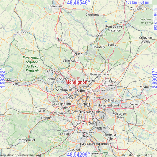
Montlignon GPS coordinates[2]
49° 0' 22.896" North, 2° 17' 13.38" East
| Map corner | latitude | longitude |
|---|---|---|
| Upper-left | 49.46546°, | 1.58392° |
| Center: | 49.00636°, | 2.28705° |
| Lower-right: | 48.54299°, | 2.99017° |
| Map W x H: | 102.6×102.6 km | = 63.8×63.8mi |
| max Lat: | 51.07786° ⇑20.2% North |
| Montlignon: | 49.00636° |
| min Lat: | ⇓79.8% South 41.3874° |
| min Long | Montlignon | max Long |
| -5.08615° | 2.28705° | 9.52242° |
| W 47.1%⇐ | ⇒52.9% E |
Elevation
Elevation of Montlignon is 74 m = 243 ft, and this is 119.7 m = 393 ft below average elevation for this country.
| Max E: |
2333 m = 7654 ft | 71.9% |
| Avg. | 193.7 m = 635 ft | |
| Montlignon | 74 m = 243 ft | |
Min E: |
-1 m = -3 ft | 28.1% |
See also: France elevation on elevation.city.
Geographical zone
Montlignon is located in North temperate zone (between Tropic of Cancer and the Arctic Circle). Distance of this North polar circle is 1952.2 km =1213 mi to North.| Distance of | km | miles | from Montlignon |
|---|---|---|---|
| North Pole | 4558.1 | 2832.3 | to North |
| Arctic Circle | 1952.2 | 1213 | to North |
| Tropic Cancer | 2843.1 | 1766.6 | to South |
| Equator | 5449 | 3385.9 | to South |


Nearby cities:
15 places around Montlignon: (largest is in red/bold)
• Andilly
1.2 km =0.7 mi,  73°
73°
• Bouffémont
4.2 km =2.6 mi,  10°
10°
• Deuil-la-Barre
4.4 km =2.7 mi,  138°
138°
• Domont
3.7 km =2.3 mi,  50°
50°
• Eaubonne
1.1 km =0.7 mi,  197°
197°
• Ermont
2.8 km =1.7 mi,  229°
229°
• Franconville
4.7 km =2.9 mi,  236°
236°
• Le Plessis-Bouchard
4 km =2.5 mi,  259°
259°
• Margency
1.2 km =0.7 mi,  126°
126°
• Montmorency
4.6 km =2.9 mi,  116°
116°
• Piscop
4.3 km =2.7 mi,  81°
81°
• Saint-Gratien
3.7 km =2.3 mi,  179°
179°
• Saint-Leu-la-Forêt
2.9 km =1.8 mi,  292°
292°
• Saint-Prix
1.9 km =1.2 mi,  307°
307°
• Soisy-sous-Montmorency
2.3 km =1.4 mi,  152°
152°
Sources, notices
• [Note1] Compared only with cities in France existing in our database
• [Src1] Map data: © OpenStreetMap contributors (CC-BY-SA)
• [Src2] Other city data from geonames.org with taken over terms of usage.
• [Src3] Geographical zone / Annual Mean Temperature by Robert A. Rohde @ Wikipedia
