Théoule-sur-Mer geodata
Théoule-sur-Mer (Provence-Alpes-Côte d'Azur) is a populated place; located in France in Europe/Paris (GMT+2) time zone. With population of 1,347 people, there are 6827 cities with bigger population in this country. Compared to other cities in France, 93% of cities are located further ↑North; 94.5% of cities are located further ←West and 97% of cities have higher elevation than Théoule-sur-Mer. Note1
Administrative division(s):
- Level 1: Provence-Alpes-Côte d'Azur
- Level 2: Alpes-Maritimes
- Level 3: Arrondissement de Grasse
- Level 4: Théoule-sur-Mer


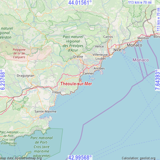
Théoule-sur-Mer GPS coordinates[2]
43° 30' 28.08" North, 6° 56' 26.88" East
| Map corner | latitude | longitude |
|---|---|---|
| Upper-left | 44.01561°, | 6.23768° |
| Center: | 43.5078°, | 6.9408° |
| Lower-right: | 42.99568°, | 7.64393° |
| Map W x H: | 113.4×113.4 km | = 70.5×70.5mi |
| max Lat: | 51.07786° ⇑93% North |
| Théoule-sur-Mer: | 43.5078° |
| min Lat: | ⇓7% South 41.3874° |
| min Long | Théoule-sur-Me | max Long |
| -5.08615° | 6.9408° | 9.52242° |
| W 94.5%⇐ | ⇒5.5% E |
Elevation
Elevation of Théoule-sur-Mer is 11 m = 36 ft, and this is 182.7 m = 599 ft below average elevation for this country.
| Max E: |
2333 m = 7654 ft | 97% |
| Avg. | 193.7 m = 635 ft | |
| Théoule-sur-Mer | 11 m = 36 ft | |
Min E: |
-1 m = -3 ft | 3% |
See also: France elevation on elevation.city.
Geographical zone
Théoule-sur-Mer is located in North temperate zone (between Tropic of Cancer and the Arctic Circle). Distance of this Northern Tropic circle is 2231.7 km =1386.7 mi to South.| Distance of | km | miles | from Théoule-sur-Mer |
|---|---|---|---|
| North Pole | 5169.4 | 3212.1 | to North |
| Arctic Circle | 2563.6 | 1592.9 | to North |
| Tropic Cancer | 2231.7 | 1386.7 | to South |
| Equator | 4837.6 | 3005.9 | to South |


Nearby cities:
15 places around Théoule-sur-Mer: (largest is in red/bold)
• Antibes
16 km =9.9 mi,  57°
57°
• Auribeau-sur-Siagne
10.6 km =6.6 mi,  346°
346°
• Cannes
7.6 km =4.7 mi,  50°
50°
• La Roquette-sur-Siagne
10.2 km =6.3 mi,  7°
7°
• Le Cannet
9.9 km =6.2 mi,  39°
39°
• Le Tignet
16.5 km =10.3 mi,  332°
332°
• Mandelieu-la-Napoule
4.2 km =2.6 mi,  356°
356°
• Mouans-Sartoux
12.8 km =8 mi, 11°
• Mougins
11.2 km =7 mi,  23°
23°
• Peymeinade
15.9 km =9.9 mi,  340°
340°
• Pégomas
9.9 km =6.2 mi, 355°
• Saint-Raphaël
16.4 km =10.2 mi,  235°
235°
• Tanneron
10.6 km =6.6 mi, 330°
• Valbonne
14.7 km =9.1 mi, 18°
• Vallauris
12 km =7.5 mi, 49°
Sources, notices
• [Note1] Compared only with cities in France existing in our database
• [Src1] Map data: © OpenStreetMap contributors (CC-BY-SA)
• [Src2] Other city data from geonames.org with taken over terms of usage.
• [Src3] Geographical zone / Annual Mean Temperature by Robert A. Rohde @ Wikipedia
