Mandelieu-la-Napoule geodata
Mandelieu-la-Napoule (Provence-Alpes-Côte d'Azur) is a populated place; located in France in Europe/Paris (GMT+2) time zone. With population of 19,292 people, there are 476 cities with bigger population in this country. Compared to other cities in France, 92.5% of cities are located further ↑North; 94.5% of cities are located further ←West and 99.8% of cities have higher elevation than Mandelieu-la-Napoule. Note1
Administrative division(s):
- Level 1: Provence-Alpes-Côte d'Azur
- Level 2: Alpes-Maritimes
- Level 3: Arrondissement de Grasse
- Level 4: Mandelieu-la-Napoule


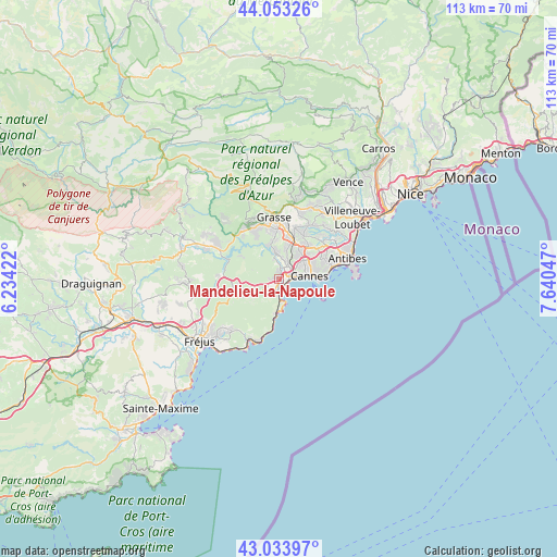
Mandelieu-la-Napoule GPS coordinates[2]
43° 32' 44.772" North, 6° 56' 14.424" East
| Map corner | latitude | longitude |
|---|---|---|
| Upper-left | 44.05326°, | 6.23422° |
| Center: | 43.54577°, | 6.93734° |
| Lower-right: | 43.03397°, | 7.64047° |
| Map W x H: | 113.3×113.3 km | = 70.4×70.4mi |
| max Lat: | 51.07786° ⇑92.5% North |
| Mandelieu-la-Napoule: | 43.54577° |
| min Lat: | ⇓7.5% South 41.3874° |
| min Long | Mandelieu-la-Na | max Long |
| -5.08615° | 6.93734° | 9.52242° |
| W 94.5%⇐ | ⇒5.5% E |
Elevation
Elevation of Mandelieu-la-Napoule is 3 m = 10 ft, and this is 190.7 m = 626 ft below average elevation for this country.
| Max E: |
2333 m = 7654 ft | 99.8% |
| Avg. | 193.7 m = 635 ft | |
| Mandelieu-la-Napoule | 3 m = 10 ft | |
Min E: |
-1 m = -3 ft | 0.2% |
See also: France elevation on elevation.city.
Geographical zone
Mandelieu-la-Napoule is located in North temperate zone (between Tropic of Cancer and the Arctic Circle). Distance of this Northern Tropic circle is 2235.9 km =1389.3 mi to South.| Distance of | km | miles | from Mandelieu-la-Napoule |
|---|---|---|---|
| North Pole | 5165.2 | 3209.5 | to North |
| Arctic Circle | 2559.3 | 1590.3 | to North |
| Tropic Cancer | 2235.9 | 1389.3 | to South |
| Equator | 4841.8 | 3008.6 | to South |


Nearby cities:
15 places around Mandelieu-la-Napoule: (largest is in red/bold)
• Auribeau-sur-Siagne
6.5 km =4 mi,  340°
340°
• Cannes
6.1 km =3.8 mi,  84°
84°
• Grasse
12.5 km =7.8 mi,  355°
355°
• La Roquette-sur-Siagne
6.1 km =3.8 mi,  14°
14°
• Le Cannet
7.4 km =4.6 mi,  62°
62°
• Le Tignet
12.8 km =8 mi,  324°
324°
• Mouans-Sartoux
8.8 km =5.5 mi,  18°
18°
• Mougins
7.7 km =4.8 mi,  37°
37°
• Peymeinade
11.8 km =7.3 mi, 335°
• Pégomas
5.7 km =3.5 mi, 355°
• Spéracèdes
13.1 km =8.1 mi,  331°
331°
• Tanneron
7.1 km =4.4 mi,  314°
314°
• Théoule-sur-Mer
4.2 km =2.6 mi,  176°
176°
• Valbonne
10.9 km =6.8 mi,  27°
27°
• Vallauris
10.1 km =6.3 mi,  69°
69°
In other languages:
- In France: Mandelieu-La Napoule
- In Russian: Мандельё-ла-Напуль
- In Chinese: 芒代利厄拉納普爾
Sources, notices
• [Note1] Compared only with cities in France existing in our database
• [Src1] Map data: © OpenStreetMap contributors (CC-BY-SA)
• [Src2] Other city data from geonames.org with taken over terms of usage.
• [Src3] Geographical zone / Annual Mean Temperature by Robert A. Rohde @ Wikipedia
