Taisnières-sur-Hon geodata
Taisnières-sur-Hon (Hauts-de-France) is a populated place; located in France in Europe/Paris (GMT+2) time zone. With population of 851 people, there are 10072 cities with bigger population in this country. Compared to other cities in France, 95.8% of cities are located further ↓South; 66.5% of cities are located further ←West and 53.3% of cities have lower elevation than Taisnières-sur-Hon. Note1
Administrative division(s):
- Level 1: Hauts-de-France
- Level 2: Nord
- Level 3: Avesnes-sur-Helpe
- Level 4: Taisnières-sur-Hon


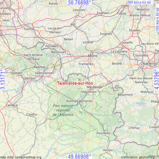
Taisnières-sur-Hon GPS coordinates[2]
50° 19' 12.54" North, 3° 50' 5.388" East
| Map corner | latitude | longitude |
|---|---|---|
| Upper-left | 50.76698°, | 3.13171° |
| Center: | 50.32015°, | 3.83483° |
| Lower-right: | 49.86908°, | 4.53796° |
| Map W x H: | 99.8×99.8 km | = 62×62mi |
| max Lat: | 51.07786° ⇑4.2% North |
| Taisnières-sur-Hon: | 50.32015° |
| min Lat: | ⇓95.8% South 41.3874° |
| min Long | Taisnières-sur | max Long |
| -5.08615° | 3.83483° | 9.52242° |
| W 66.5%⇐ | ⇒33.5% E |
Elevation
Elevation of Taisnières-sur-Hon is 144 m = 472 ft, and this is 49.7 m = 163 ft below average elevation for this country.
| Max E: |
2333 m = 7654 ft | 46.7% |
| Avg. | 193.7 m = 635 ft | |
| Taisnières-sur-Hon | 144 m = 472 ft | |
Min E: |
-1 m = -3 ft | 53.3% |
See also: France elevation on elevation.city.
Geographical zone
Taisnières-sur-Hon is located in North temperate zone (between Tropic of Cancer and the Arctic Circle). Distance of this North polar circle is 1806.1 km =1122.3 mi to North.| Distance of | km | miles | from Taisnières-sur-Hon |
|---|---|---|---|
| North Pole | 4412 | 2741.5 | to North |
| Arctic Circle | 1806.1 | 1122.3 | to North |
| Tropic Cancer | 2989.2 | 1857.4 | to South |
| Equator | 5595.1 | 3476.6 | to South |


Nearby cities:
15 places around Taisnières-sur-Hon: (largest is in red/bold)
• Bavay
3.8 km =2.4 mi,  230°
230°
• Bellignies
4.7 km =2.9 mi,  278°
278°
• Feignies
6.2 km =3.9 mi,  113°
113°
• Gommegnies
10.6 km =6.6 mi,  239°
239°
• Hautmont
9.9 km =6.2 mi,  141°
141°
• Hon-Hergies
1.4 km =0.9 mi,  301°
301°
• Houdain-lez-Bavay
3.6 km =2.2 mi,  259°
259°
• La Longueville
3.8 km =2.4 mi,  155°
155°
• Louvroil
11 km =6.8 mi,  124°
124°
• Maubeuge
10.8 km =6.7 mi, 115°
• Mecquignies
5.6 km =3.5 mi,  211°
211°
• Obies
6.8 km =4.2 mi, 211°
• Pont-sur-Sambre
11 km =6.8 mi,  175°
175°
• Vieux-Mesnil
7.7 km =4.8 mi,  165°
165°
• Wargnies-le-Petit
11.8 km =7.3 mi, 255°
Sources, notices
• [Note1] Compared only with cities in France existing in our database
• [Src1] Map data: © OpenStreetMap contributors (CC-BY-SA)
• [Src2] Other city data from geonames.org with taken over terms of usage.
• [Src3] Geographical zone / Annual Mean Temperature by Robert A. Rohde @ Wikipedia
