Bavay geodata
Bavay (Hauts-de-France) is a populated place; located in France in Europe/Paris (GMT+2) time zone. With population of 3,414 people, there are 2850 cities with bigger population in this country. Compared to other cities in France, 95.5% of cities are located further ↓South; 66.3% of cities are located further ←West and 54.7% of cities have lower elevation than Bavay. Note1
Administrative division(s):
- Level 1: Hauts-de-France
- Level 2: Nord
- Level 3: Avesnes-sur-Helpe
- Level 4: Bavay


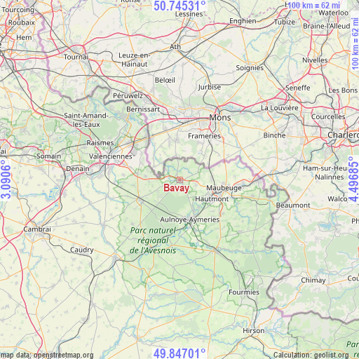
Bavay GPS coordinates[2]
50° 17' 53.808" North, 3° 47' 37.392" East
| Map corner | latitude | longitude |
|---|---|---|
| Upper-left | 50.74531°, | 3.0906° |
| Center: | 50.29828°, | 3.79372° |
| Lower-right: | 49.84701°, | 4.49685° |
| Map W x H: | 99.9×99.9 km | = 62.1×62.1mi |
| max Lat: | 51.07786° ⇑4.5% North |
| Bavay: | 50.29828° |
| min Lat: | ⇓95.5% South 41.3874° |
| min Long | Bavay | max Long |
| -5.08615° | 3.79372° | 9.52242° |
| W 66.3%⇐ | ⇒33.7% E |
Elevation
Elevation of Bavay is 149 m = 489 ft, and this is 44.7 m = 147 ft below average elevation for this country.
| Max E: |
2333 m = 7654 ft | 45.3% |
| Avg. | 193.7 m = 635 ft | |
| Bavay | 149 m = 489 ft | |
Min E: |
-1 m = -3 ft | 54.7% |
See also: France elevation on elevation.city.
Geographical zone
Bavay is located in North temperate zone (between Tropic of Cancer and the Arctic Circle). Distance of this North polar circle is 1808.5 km =1123.7 mi to North.| Distance of | km | miles | from Bavay |
|---|---|---|---|
| North Pole | 4414.4 | 2743 | to North |
| Arctic Circle | 1808.5 | 1123.7 | to North |
| Tropic Cancer | 2986.7 | 1855.8 | to South |
| Equator | 5592.6 | 3475.1 | to South |


Nearby cities:
15 places around Bavay: (largest is in red/bold)
• Bellignies
3.6 km =2.2 mi,  330°
330°
• Feignies
8.6 km =5.3 mi,  90°
90°
• Gommegnies
6.9 km =4.3 mi,  244°
244°
• Hautmont
10.5 km =6.5 mi,  120°
120°
• Hon-Hergies
3.6 km =2.2 mi,  28°
28°
• Houdain-lez-Bavay
1.9 km =1.2 mi,  339°
339°
• La Longueville
4.6 km =2.9 mi,  102°
102°
• Mecquignies
2.4 km =1.5 mi,  179°
179°
• Obies
3.4 km =2.1 mi,  190°
190°
• Pont-sur-Sambre
9.3 km =5.8 mi,  155°
155°
• Taisnières-sur-Hon
3.8 km =2.4 mi,  50°
50°
• Vieux-Mesnil
7 km =4.3 mi,  136°
136°
• Villereau
10.3 km =6.4 mi, 242°
• Wargnies-le-Grand
9.5 km =5.9 mi,  276°
276°
• Wargnies-le-Petit
8.6 km =5.3 mi,  266°
266°
Sources, notices
• [Note1] Compared only with cities in France existing in our database
• [Src1] Map data: © OpenStreetMap contributors (CC-BY-SA)
• [Src2] Other city data from geonames.org with taken over terms of usage.
• [Src3] Geographical zone / Annual Mean Temperature by Robert A. Rohde @ Wikipedia
