Maubeuge geodata
Maubeuge (Hauts-de-France) is a populated place; located in France in Europe/Paris (GMT+2) time zone. With population of 33,684 people, there are 232 cities with bigger population in this country. Compared to other cities in France, 95.3% of cities are located further ↓South; 67.5% of cities are located further ←West and 53.1% of cities have lower elevation than Maubeuge. Note1
Administrative division(s):
- Level 1: Hauts-de-France
- Level 2: Nord
- Level 3: Avesnes-sur-Helpe
- Level 4: Maubeuge


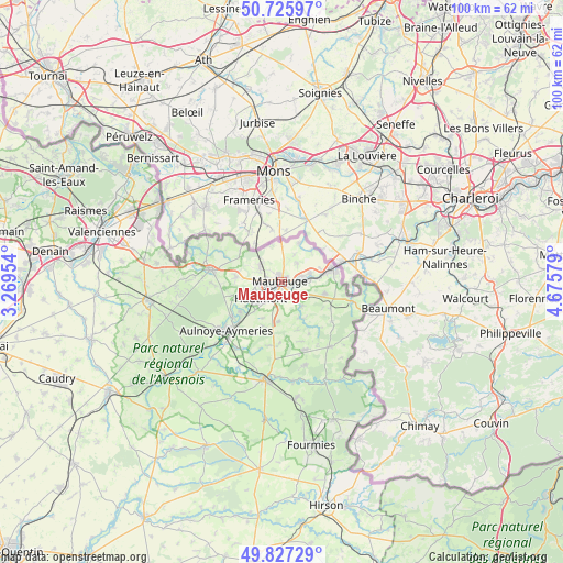
Maubeuge GPS coordinates[2]
50° 16' 43.5" North, 3° 58' 21.612" East
| Map corner | latitude | longitude |
|---|---|---|
| Upper-left | 50.72597°, | 3.26954° |
| Center: | 50.27875°, | 3.97267° |
| Lower-right: | 49.82729°, | 4.67579° |
| Map W x H: | 99.9×99.9 km | = 62.1×62.1mi |
| max Lat: | 51.07786° ⇑4.7% North |
| Maubeuge: | 50.27875° |
| min Lat: | ⇓95.3% South 41.3874° |
| min Long | Maubeuge | max Long |
| -5.08615° | 3.97267° | 9.52242° |
| W 67.5%⇐ | ⇒32.5% E |
Elevation
Elevation of Maubeuge is 143 m = 469 ft, and this is 50.7 m = 166 ft below average elevation for this country.
| Max E: |
2333 m = 7654 ft | 46.9% |
| Avg. | 193.7 m = 635 ft | |
| Maubeuge | 143 m = 469 ft | |
Min E: |
-1 m = -3 ft | 53.1% |
See also: France elevation on elevation.city.
Geographical zone
Maubeuge is located in North temperate zone (between Tropic of Cancer and the Arctic Circle). Distance of this North polar circle is 1810.7 km =1125.1 mi to North.| Distance of | km | miles | from Maubeuge |
|---|---|---|---|
| North Pole | 4416.6 | 2744.3 | to North |
| Arctic Circle | 1810.7 | 1125.1 | to North |
| Tropic Cancer | 2984.6 | 1854.5 | to South |
| Equator | 5590.5 | 3473.8 | to South |


Nearby cities:
15 places around Maubeuge: (largest is in red/bold)
• Bachant
10.2 km =6.3 mi,  226°
226°
• Boussois
5 km =3.1 mi,  76°
76°
• Colleret
8.1 km =5 mi,  107°
107°
• Feignies
4.6 km =2.9 mi,  297°
297°
• Ferrière-la-Grande
3 km =1.9 mi,  151°
151°
• Hautmont
4.8 km =3 mi, 229°
• Jeumont
9.3 km =5.8 mi, 77°
• La Longueville
8.3 km =5.2 mi,  278°
278°
• Louvroil
1.8 km =1.1 mi,  203°
203°
• Marpent
7.7 km =4.8 mi, 78°
• Pont-sur-Sambre
10.9 km =6.8 mi, 234°
• Recquignies
4.6 km =2.9 mi, 82°
• Rousies
2.3 km =1.4 mi,  104°
104°
• Taisnières-sur-Hon
10.8 km =6.7 mi, 295°
• Vieux-Mesnil
8.4 km =5.2 mi,  250°
250°
Sources, notices
• [Note1] Compared only with cities in France existing in our database
• [Src1] Map data: © OpenStreetMap contributors (CC-BY-SA)
• [Src2] Other city data from geonames.org with taken over terms of usage.
• [Src3] Geographical zone / Annual Mean Temperature by Robert A. Rohde @ Wikipedia
