Sète geodata
Sète (Occitanie) is a populated place; located in France in Europe/Paris (GMT+2) time zone. With population of 40,736 people, there are 177 cities with bigger population in this country. Compared to other cities in France, 94.2% of cities are located further ↑North; 65.7% of cities are located further ←West and 87.4% of cities have higher elevation than Sète. Note1
Administrative division(s):
- Level 1: Occitanie
- Level 2: Département de l'Hérault
- Level 3: Arrondissement of Montpellier
- Level 4: Sète


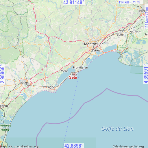
Sète GPS coordinates[2]
43° 24' 10.08" North, 3° 41' 34.008" East
| Map corner | latitude | longitude |
|---|---|---|
| Upper-left | 43.91149°, | 2.98966° |
| Center: | 43.4028°, | 3.69278° |
| Lower-right: | 42.8898°, | 4.39591° |
| Map W x H: | 113.6×113.6 km | = 70.6×70.6mi |
| max Lat: | 51.07786° ⇑94.2% North |
| Sète: | 43.4028° |
| min Lat: | ⇓5.8% South 41.3874° |
| min Long | Sète | max Long |
| -5.08615° | 3.69278° | 9.52242° |
| W 65.7%⇐ | ⇒34.3% E |
Elevation
Elevation of Sète is 36 m = 118 ft, and this is 157.7 m = 517 ft below average elevation for this country.
| Max E: |
2333 m = 7654 ft | 87.4% |
| Avg. | 193.7 m = 635 ft | |
| Sète | 36 m = 118 ft | |
Min E: |
-1 m = -3 ft | 12.6% |
See also: Sète elevation on elevation.city.
Geographical zone
Sète is located in North temperate zone (between Tropic of Cancer and the Arctic Circle). Distance of this Northern Tropic circle is 2220 km =1379.4 mi to South.| Distance of | km | miles | from Sète |
|---|---|---|---|
| North Pole | 5181.1 | 3219.4 | to North |
| Arctic Circle | 2575.2 | 1600.2 | to North |
| Tropic Cancer | 2220 | 1379.4 | to South |
| Equator | 4825.9 | 2998.7 | to South |


Nearby cities:
15 places around Sète: (largest is in red/bold)
• Balaruc-le-Vieux
6.5 km =4 mi,  354°
354°
• Balaruc-les-Bains
4.5 km =2.8 mi,  344°
344°
• Bouzigues
5.8 km =3.6 mi,  330°
330°
• Frontignan
7.1 km =4.4 mi,  44°
44°
• Gigean
10.9 km =6.8 mi,  8°
8°
• Loupian
8.2 km =5.1 mi,  308°
308°
• Marseillan
14.3 km =8.9 mi,  248°
248°
• Mireval
14.7 km =9.1 mi, 36°
• Montbazin
12.7 km =7.9 mi,  1°
1°
• Mèze
7.4 km =4.6 mi,  289°
289°
• Pinet
14.8 km =9.2 mi,  271°
271°
• Pomérols
15.7 km =9.8 mi, 265°
• Poussan
9.8 km =6.1 mi, 349°
• Vic-la-Gardiole
12.9 km =8 mi, 40°
• Villeveyrac
12.9 km =8 mi, 327°
Sources, notices
• [Note1] Compared only with cities in France existing in our database
• [Src1] Map data: © OpenStreetMap contributors (CC-BY-SA)
• [Src2] Other city data from geonames.org with taken over terms of usage.
• [Src3] Geographical zone / Annual Mean Temperature by Robert A. Rohde @ Wikipedia
