Mèze geodata
Mèze (Occitanie) is a populated place; located in France in Europe/Paris (GMT+2) time zone. With population of 8,557 people, there are 1126 cities with bigger population in this country. Compared to other cities in France, 94% of cities are located further ↑North; 65.1% of cities are located further ←West and 98.2% of cities have higher elevation than Mèze. Note1
Administrative division(s):
- Level 1: Occitanie
- Level 2: Département de l'Hérault
- Level 3: Arrondissement of Montpellier
- Level 4: Mèze


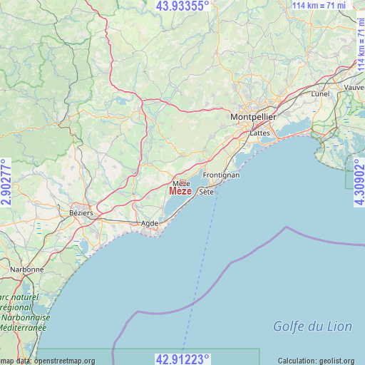
Mèze GPS coordinates[2]
43° 25' 30.144" North, 3° 36' 21.24" East
| Map corner | latitude | longitude |
|---|---|---|
| Upper-left | 43.93355°, | 2.90277° |
| Center: | 43.42504°, | 3.6059° |
| Lower-right: | 42.91223°, | 4.30902° |
| Map W x H: | 113.6×113.6 km | = 70.6×70.6mi |
| max Lat: | 51.07786° ⇑94% North |
| Mèze: | 43.42504° |
| min Lat: | ⇓6% South 41.3874° |
| min Long | Mèze | max Long |
| -5.08615° | 3.6059° | 9.52242° |
| W 65.1%⇐ | ⇒34.9% E |
Elevation
Elevation of Mèze is 8 m = 26 ft, and this is 185.7 m = 609 ft below average elevation for this country.
| Max E: |
2333 m = 7654 ft | 98.2% |
| Avg. | 193.7 m = 635 ft | |
| Mèze | 8 m = 26 ft | |
Min E: |
-1 m = -3 ft | 1.8% |
See also: France elevation on elevation.city.
Geographical zone
Mèze is located in North temperate zone (between Tropic of Cancer and the Arctic Circle). Distance of this Northern Tropic circle is 2222.5 km =1381 mi to South.| Distance of | km | miles | from Mèze |
|---|---|---|---|
| North Pole | 5178.7 | 3217.9 | to North |
| Arctic Circle | 2572.8 | 1598.7 | to North |
| Tropic Cancer | 2222.5 | 1381 | to South |
| Equator | 4828.4 | 3000.2 | to South |


Nearby cities:
15 places around Mèze: (largest is in red/bold)
• Balaruc-le-Vieux
7.6 km =4.7 mi,  57°
57°
• Balaruc-les-Bains
6.1 km =3.8 mi,  72°
72°
• Bouzigues
4.9 km =3 mi, 58°
• Florensac
12.2 km =7.6 mi,  247°
247°
• Frontignan
12.2 km =7.6 mi,  77°
77°
• Gigean
12 km =7.5 mi,  45°
45°
• Loupian
2.7 km =1.7 mi,  13°
13°
• Marseillan
9.9 km =6.2 mi,  219°
219°
• Montagnac
11.7 km =7.3 mi,  302°
302°
• Pinet
8 km =5 mi, 254°
• Pomérols
9.4 km =5.8 mi, 246°
• Poussan
8.9 km =5.5 mi,  36°
36°
• Saint-Pons-de-Mauchiens
12.2 km =7.6 mi,  323°
323°
• Sète
7.4 km =4.6 mi,  109°
109°
• Villeveyrac
8.4 km =5.2 mi,  0°
0°
Sources, notices
• [Note1] Compared only with cities in France existing in our database
• [Src1] Map data: © OpenStreetMap contributors (CC-BY-SA)
• [Src2] Other city data from geonames.org with taken over terms of usage.
• [Src3] Geographical zone / Annual Mean Temperature by Robert A. Rohde @ Wikipedia
